
Pine Mountain Club topographic map
Interactive map
Click on the map to display elevation.
About this map
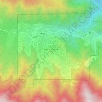
Name: Pine Mountain Club topographic map, elevation, terrain.
Average elevation: 1,867 m
Minimum elevation: 1,328 m
Maximum elevation: 2,548 m
Pine Mountain Club has an area of 16.7 square miles (43.25 km2). It ranges from 4,901 to 6,400 feet (1,494 to 1,951 m) in elevation. The community sits in a deep valley of the San Emigdio Mountains, on the San Andreas fault. It is surrounded by Los Padres National Forest. The settlement lies between Apache Saddle and Pinon Pines Estates along Mil Potrero Highway. It is west of Frazier Park, Lebec, and Interstate 5.