
La Zoma topographic map
Interactive map
Click on the map to display elevation.
About this map
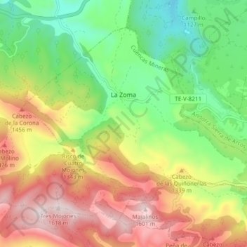
Name: La Zoma topographic map, elevation, terrain.
Location: La Zoma, Cuencas Mineras, Teruel, Aragon, Spain (40.75607 -0.65012 40.79948 -0.57639)
Average elevation: 1,256 m
Minimum elevation: 971 m
Maximum elevation: 1,614 m
Other topographic maps
Click on a map to view its topography, its elevation and its terrain.
Utrillas
Spain > Aragon > Cuencas Mineras
Utrillas, Cuencas Mineras, Teruel, Aragon, 44760, Spain
Average elevation: 1,159 m