
Leedstown topographic map
Interactive map
Click on the map to display elevation.
About this map
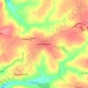
Name: Leedstown topographic map, elevation, terrain.
Location: Leedstown, Cornwall, England, TR27 6DB, United Kingdom (50.14074 -5.37560 50.18074 -5.33560)
Average elevation: 73 m
Minimum elevation: 27 m
Maximum elevation: 103 m
Other topographic maps
Click on a map to view its topography, its elevation and its terrain.
Perranporth
United Kingdom > England > Cornwall
Perranporth, Perranzabuloe, Cornwall, England, TR6 0HR, United Kingdom
Average elevation: 43 m
Polkerris
United Kingdom > England > Cornwall > Fowey
Polkerris, Fowey, Cornwall, England, PL24 2TL, United Kingdom
Average elevation: 35 m
Bude
United Kingdom > England > Cornwall
Bude, Cornwall, England, EX23 8LD, United Kingdom
Average elevation: 39 m