
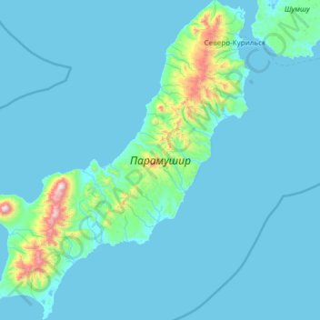
Paramushir topographic map
Interactive map
Click on the map to display elevation.
About this map
Name: Paramushir topographic map, elevation, terrain.
Average elevation: 94 m
Minimum elevation: -1 m
Maximum elevation: 1,756 m
Other topographic maps
Click on a map to view its topography, its elevation and its terrain.
Saratovskaya
Russia > Sakhalin Oblast > Yuzhno-Kurilsky District
Saratovskaya, Yuzhno-Kurilsky District, Sakhalin Oblast, Far Eastern Federal District, Russia
Average elevation: 80 m
Strait of Tartary
Russia > Sakhalin Oblast > Kolkhoznoye
Strait of Tartary, улица Гагарина, Kolkhoznoye, Nevelsky District, Sakhalin Oblast, Far Eastern Federal District, 694752, Russia
Average elevation: 201 m
Сноу
Сноу, Kurilsky District, Sakhalin Oblast, Far Eastern Federal District, Russia
Average elevation: 162 m
Sakhalin
Sakhalin, Smirnykhovsky District, Sakhalin Oblast, Far Eastern Federal District, Russia
Average elevation: 119 m
Urup
Urup, Kurilsky District, Sakhalin Oblast, Far Eastern Federal District, Russia
Average elevation: 54 m