
Marks Point topographic map
Interactive map
Click on the map to display elevation.
About this map
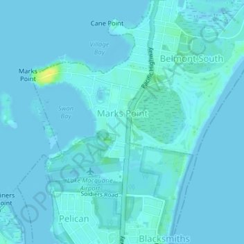
Name: Marks Point topographic map, elevation, terrain.
Average elevation: 2 m
Minimum elevation: -3 m
Maximum elevation: 20 m
Other topographic maps
Click on a map to view its topography, its elevation and its terrain.
Blacksmiths
Australia > New South Wales > Newcastle-Maitland
Blacksmiths, Newcastle-Maitland, Lake Macquarie City Council, New South Wales, 2281, Australia
Average elevation: 1 m
Newcastle
Australia > New South Wales > Newcastle-Maitland
Newcastle, Newcastle-Maitland, Newcastle City Council, New South Wales, 2300, Australia
Average elevation: 5 m