
Cheddar topographic map
Interactive map
Click on the map to display elevation.
About this map
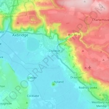
Name: Cheddar topographic map, elevation, terrain.
Location: Cheddar, Somerset, England, United Kingdom (51.23585 -2.83912 51.30903 -2.70989)
Average elevation: 109 m
Minimum elevation: 3 m
Maximum elevation: 325 m
Other topographic maps
Click on a map to view its topography, its elevation and its terrain.
Huish Episcopi
United Kingdom > England > Somerset > South Somerset > Huish Episcopi
Huish Episcopi, South Somerset, Somerset, South West England, England, United Kingdom
Average elevation: 29 m