
Europe topographic map
Interactive map
Click on the map to display elevation.
About this map
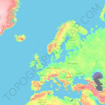
Name: Europe topographic map, elevation, terrain.
Location: Europe (26.00000 -15.00000 76.00000 35.00000)
Average elevation: 223 m
Minimum elevation: -30 m
Maximum elevation: 3,987 m
In general, Europe is not just colder towards the north compared to the south, but it also gets colder from the west towards the east. The climate is more oceanic in the west and less so in the east. This can be illustrated by the following table of average temperatures at locations roughly following the 64th, 60th, 55th, 50th, 45th and 40th latitudes. None of them is located at high altitude; most of them are close to the sea. (location, approximate latitude and longitude, coldest month average, hottest month average and annual average temperatures in degrees C)
Other topographic maps
Click on a map to view its topography, its elevation and its terrain.
Ireland
Ireland
Average elevation: 44 m
Chasiv Yar
Chasiv Yar, Chasiv Yar urban hromada, Bakhmut Raion, Donetsk Oblast, 84551-84556, Ukraine
Average elevation: 213 m
Czechia
Czechia
Average elevation: 369 m
Nacogdoches County
Nacogdoches County, Texas, United States
Average elevation: 93 m
Taiwan
Taiwan > Taiwan Province > Xinyi Township
Taiwan, Xinyi Township, Nantou County, Taiwan Province, Taiwan
Average elevation: 196 m
El Salvador
El Salvador
Average elevation: 484 m
Bangladesh
Bangladesh
Average elevation: 161 m
Cork
Ireland > County Cork > Cork
Cork, County Cork, Munster, T12 T997, Ireland
Average elevation: 94 m
Madagascar
Madagascar
Average elevation: 139 m
Tooele County
United States of America > Utah
Tooele County, Utah, United States of America
Average elevation: 1,462 m
El Dorado County
El Dorado County, California, United States
Average elevation: 1,286 m
High Wycombe
United Kingdom > England > Buckinghamshire
High Wycombe, Buckinghamshire, England, United Kingdom
Average elevation: 124 m
Croatia
Croatia
Average elevation: 323 m
Stone Canyon Reservoir & Watershed
United States > California > Los Angeles
Stone Canyon Reservoir & Watershed, Bel Air Road, Beverly Glen, Los Angeles, California, 90077, United States
Average elevation: 341 m
Barton-upon-Humber
United Kingdom > England > North Lincolnshire
Barton-upon-Humber, North Lincolnshire, England, DN18 5QP, United Kingdom
Average elevation: 24 m
Kilnaleck
Kilnaleck, Ballyjamesduff Municipal District, County Cavan, A82 X567, Ireland
Average elevation: 114 m
Toliara
Toliara, Atsimo-Andrefana, Province de Toliara, 601, Madagascar
Average elevation: 38 m
Unity
United States > Maine > Waldo County
Unity, Waldo County, Maine, United States
Average elevation: 95 m
Latvia
Latvia
Average elevation: 72 m
Toblach - Dobbiaco
Italy > Trentino – Alto Adige/Südtirol > South Tyrol
Toblach - Dobbiaco, Pustertal - Val Pusteria, South Tyrol, Trentino – Alto Adige/Südtirol, 39034, Italy
Average elevation: 1,813 m
Galway City
Galway, Galway City, County Galway, Connacht, H91 YD86, Ireland
Average elevation: 26 m
Newquay
Newquay, Abbey ED, West Clare Municipal District, County Clare, Munster, Ireland
Average elevation: 7 m
Nasugbu
Nasugbu, Batangas, Calabarzon, 4231, Philippines
Average elevation: 71 m
Lausanne
Switzerland > Vaud > District de Lausanne
Lausanne, District de Lausanne, Vaud, Switzerland
Average elevation: 621 m
Valencia
Spain > Valencian Community > Comarca de València
Valencia, Comarca de València, Valencia, Valencian Community, Spain
Average elevation: 37 m
Kilmihil
Kilmihil, West Clare Municipal District, County Clare, Munster, Ireland
Average elevation: 69 m
Monterey County
Monterey County, California, United States
Average elevation: 282 m
Victorville
United States > California > San Bernardino County
Victorville, San Bernardino County, California, United States
Average elevation: 920 m
Great Kei Local Municipality
South Africa > Eastern Cape > Amathole District Municipality
Great Kei Local Municipality, Amathole District Municipality, Eastern Cape, South Africa
Average elevation: 295 m
Krishnapur
India > Maharashtra > Chandurbazar
Krishnapur, Chandurbazar, Amravati District, Maharashtra, India
Average elevation: 348 m
Cerro Chachagua
Cerro Chachagua, Wiwilí (Municipio), Nueva Segovia, 39100, Nicaragua
Average elevation: 901 m
Rathcormack
Rathcormack, Drumcliff South, Drumcliff West ED, Sligo Municipal Borough District, County Sligo, Connacht, F91 PY24, Ireland
Average elevation: 27 m
Miłomłyn
Poland > Warmian-Masurian Voivodeship > Ostróda County
Miłomłyn, gmina Miłomłyn, Ostróda County, Warmian-Masurian Voivodeship, 14-140, Poland
Average elevation: 109 m