
Sheepshead topographic map
Interactive map
Click on the map to display elevation.
About this map
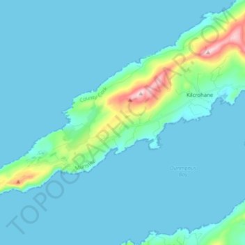
Name: Sheepshead topographic map, elevation, terrain.
Location: Sheepshead, West Cork, County Cork, Munster, Ireland (51.54013 -9.85162 51.59995 -9.69460)
Average elevation: 35 m
Minimum elevation: 0 m
Maximum elevation: 339 m
County Cork trails, hiking, mountain biking, running and outdoor activities
Other topographic maps
Click on a map to view its topography, its elevation and its terrain.