
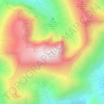
Ben Nevis topographic map
Interactive map
Click on the map to display elevation.
About this map
Name: Ben Nevis topographic map, elevation, terrain.
Location: Ben Nevis, Highland, Scotland, United Kingdom (56.79681 -5.00358 56.79691 -5.00348)
Average elevation: 912 m
Minimum elevation: 474 m
Maximum elevation: 1,338 m
Ben Nevis has a highland (alpine) maritime (oceanic) polar climate (ET climate in the Köppen classification). Ben Nevis's altitude, maritime location and topography frequently lead to cool and cloudy weather conditions, which can pose a danger to ill-equipped walkers. According to the observations carried out at the summit observatory from 1883–1904, fog was present on the summit for almost 80 per cent of the time between November and January, and 55 per cent of the time in May and June. The average winter temperature was around −5 °C (23 °F), and the mean monthly temperature for the year was −0.5 °C (31.1 °F). In an average year the summit sees 261 gales, and receives 4,350 millimetres (171 in) of rainfall, compared to only 2,050 millimetres (81 in) in nearby Fort William, 840 millimetres (33 in) in Inverness and 580 millimetres (23 in) in London. Rainfall on Ben Nevis is about twice as high in the winter as it is in the spring and summer. Snow can be found on the mountain almost all year round, particularly in the gullies of the north face – with the higher reaches of Observatory Gully holding snow until September most years and sometimes until the new snows of the following season.
Other topographic maps
Click on a map to view its topography, its elevation and its terrain.
Stob Choire Claurigh
United Kingdom > Scotland > Highland
Stob Choire Claurigh, Highland, Scotland, United Kingdom
Average elevation: 852 m
Aonach Beag
United Kingdom > Scotland > Highland
Aonach Beag, Highland, Scotland, United Kingdom
Average elevation: 825 m
Ballachulish
United Kingdom > Scotland > Highland
Ballachulish, Highland, Scotland, PH49 4JU, United Kingdom
Average elevation: 160 m
Aonach Mòr
United Kingdom > Scotland > Highland
Aonach Mòr, Highland, Scotland, United Kingdom
Average elevation: 533 m
Loch Lochy
United Kingdom > Scotland > Highland
Loch Lochy, Highland, Scotland, United Kingdom
Average elevation: 363 m
Roybridge
United Kingdom > Scotland > Highland
Roybridge, Highland, Scotland, PH31 4AE, United Kingdom
Average elevation: 178 m
Seang Aonach Mor
United Kingdom > Scotland > Highland
Seang Aonach Mor, Highland, Scotland, United Kingdom
Average elevation: 895 m
Inverroy
United Kingdom > Scotland > Highland
Inverroy, Highland, Scotland, PH31 4AQ, United Kingdom
Average elevation: 167 m
Glen Nevis
United Kingdom > Scotland > Highland
Glen Nevis, Highland, Scotland, PH33 6TE, United Kingdom
Average elevation: 178 m
Strathcarron
United Kingdom > Scotland > Highland
Strathcarron, Highland, Scotland, IV54 8YR, United Kingdom
Average elevation: 91 m
Ullapool
United Kingdom > Scotland > Highland
Ullapool, Highland, Scotland, IV26 2XE, United Kingdom
Average elevation: 150 m
Ben More Assynt
United Kingdom > Scotland > Highland
Ben More Assynt, Highland, Scotland, United Kingdom
Average elevation: 679 m
Nybster
United Kingdom > Scotland > Highland
Nybster, Highland, Scotland, KW1 4XR, United Kingdom
Average elevation: 30 m
Glen Coe
United Kingdom > Scotland > Highland > Glencoe
Glen Coe, Glencoe, Highland, Scotland, United Kingdom
Average elevation: 414 m
Loch Bealach nam Buthan
United Kingdom > Scotland > Highland
Loch Bealach nam Buthan, Highland, Scotland, United Kingdom
Average elevation: 586 m
Inverlochy
United Kingdom > Scotland > Highland > Inverlochy
Inverlochy, Highland, Scotland, PH33 6NB, United Kingdom
Average elevation: 48 m
Golspie
United Kingdom > Scotland > Highland > Golspie
Golspie, Highland, Scotland, KW10 6TF, United Kingdom
Average elevation: 61 m
Loch Shin
United Kingdom > Scotland > Highland > Lairg
Loch Shin, Lairg, Highland, Scotland, United Kingdom
Average elevation: 217 m
Fort William
United Kingdom > Scotland > Highland
Fort William, Highland, Scotland, PH33 6AQ, United Kingdom
Average elevation: 122 m
Inver
United Kingdom > Scotland > Highland
Inver, Highland, Scotland, IV20 1RY, United Kingdom
Average elevation: 8 m
Castletown
United Kingdom > Scotland > Highland
Castletown, Highland, Scotland, KW14 8UE, United Kingdom
Average elevation: 25 m
Kilmore
United Kingdom > Scotland > Highland > Ferindonald
Kilmore, Sleat, Ferindonald, Highland, Scotland, IV44 8RG, United Kingdom
Average elevation: 61 m