
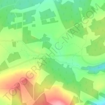
Knockaunnagun topographic map
Interactive map
Click on the map to display elevation.
About this map
Name: Knockaunnagun topographic map, elevation, terrain.
Average elevation: 202 m
Minimum elevation: 149 m
Maximum elevation: 271 m
Other topographic maps
Click on a map to view its topography, its elevation and its terrain.
Knockaderry
Ireland > The Municipal District of Newcastle West
Knockaderry, The Municipal District of Newcastle West, County Limerick, Munster, Ireland
Average elevation: 64 m
Tarbet Bay
Ireland > The Municipal District of Newcastle West
Tarbet Bay, Glin, The Municipal District of Newcastle West, County Limerick, Munster, Ireland
Average elevation: 9 m
Feohanagh
Ireland > The Municipal District of Newcastle West
Feohanagh, Broadford, The Municipal District of Newcastle West, County Limerick, Munster, Ireland
Average elevation: 72 m
Feohanagh
Ireland > The Municipal District of Newcastle West
Feohanagh, Broadford, The Municipal District of Newcastle West, County Limerick, Munster, Ireland
Average elevation: 71 m
Ardagh
Ireland > The Municipal District of Newcastle West
Ardagh, The Municipal District of Newcastle West, County Limerick, Munster, Ireland
Average elevation: 106 m
Ballintober
Ireland > The Municipal District of Newcastle West
Ballintober, The Municipal District of Newcastle West, County Limerick, Munster, Ireland
Average elevation: 122 m