
Flinders Island topographic map
Interactive map
Click on the map to display elevation.
About this map
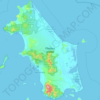
Name: Flinders Island topographic map, elevation, terrain.
Location: Flinders Island, Tasmania, Australia (-40.27409 147.74817 -39.71955 148.33210)
Average elevation: 20 m
Minimum elevation: -3 m
Maximum elevation: 737 m
Other topographic maps
Click on a map to view its topography, its elevation and its terrain.
St Pauls River
St Pauls River, Avoca, Northern Midlands, Tasmania, Australia
Average elevation: 327 m
Macquarie Island
Australia > Tasmania > Macquarie Island Station
Macquarie Island, Macquarie Island Station, Huon Valley, Tasmania, Australia
Average elevation: 20 m
Mount Nelson
Mount Nelson, Hobart, City of Hobart, Tasmania, Australia
Average elevation: 198 m
Western Junction
Australia > Tasmania > Western Junction
Western Junction, Tasmania, 7212, Australia
Average elevation: 164 m