
Gandaki topographic map
Interactive map
Click on the map to display elevation.
About this map
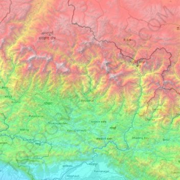
Name: Gandaki topographic map, elevation, terrain.
Location: Gandaki, Western Development Region, Nepal (27.74127 83.43972 28.90057 85.19783)
Average elevation: 2,842 m
Minimum elevation: 112 m
Maximum elevation: 7,916 m
Other topographic maps
Click on a map to view its topography, its elevation and its terrain.
Jomsom
Nepal > Western Development Region > Jomsom
Jomsom, Mustang, Dhaulagiri, Western Development Region, Nepal
Average elevation: 3,031 m
Ghandruk
Nepal > Western Development Region > Ghandruk
Ghandruk, Kaski, Gandaki, Western Development Region, Nepal
Average elevation: 3,527 m
Devadaha
Nepal > Western Development Region > Devadaha
Devadaha, Rupandehi, Lumbini, Western Development Region, Nepal
Average elevation: 295 m
Dharapani
Nepal > Western Development Region > Dharapani
Dharapani, Arghakhanchi, Lumbini, Western Development Region, Nepal
Average elevation: 1,195 m
Darling
Nepal > Western Development Region > Darling
Darling, Gulmi, Lumbini, Western Development Region, Nepal
Average elevation: 1,681 m
Annapurna II
Nepal > Western Development Region > Parche
Annapurna II, Parche, Kaski, Gandaki, Western Development Region, Nepal
Average elevation: 7,052 m
Annapurna I
Nepal > Western Development Region > Ghandruk
Annapurna I, Ghandruk, Kaski, Gandaki, Western Development Region, Nepal
Average elevation: 7,127 m
Tara
Nepal > Western Development Region > Tara
Tara, Baglung, Dhaulagiri, Western Development Region, Nepal
Average elevation: 2,315 m
Dhaulagiri
Nepal > Western Development Region > Mudi
Dhaulagiri, Mudi, Myagdi, Dhaulagiri, Western Development Region, Nepal
Average elevation: 7,321 m