
Riosucio topographic map
Interactive map
Click on the map to display elevation.
About this map
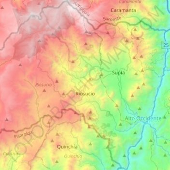
Name: Riosucio topographic map, elevation, terrain.
Location: Riosucio, Alto Occidente, Caldas, Colombia (5.33586 -75.86740 5.56355 -75.60966)
Average elevation: 2,121 m
Minimum elevation: 884 m
Maximum elevation: 3,250 m
Other topographic maps
Click on a map to view its topography, its elevation and its terrain.
Nevado del Ruiz
Nevado del Ruiz, Villamaría, Centrosur, Caldas, Colombia
Average elevation: 5,051 m