
Southwell CP topographic map
Interactive map
Click on the map to display elevation.
About this map
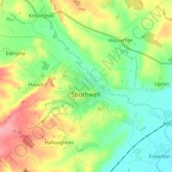
Name: Southwell CP topographic map, elevation, terrain.
Average elevation: 49 m
Minimum elevation: 12 m
Maximum elevation: 110 m
Other topographic maps
Click on a map to view its topography, its elevation and its terrain.
Bleasby
United Kingdom > England > Nottinghamshire > Newark and Sherwood
Bleasby, Newark and Sherwood, Nottinghamshire, England, NG14 7HF, United Kingdom
Average elevation: 28 m