
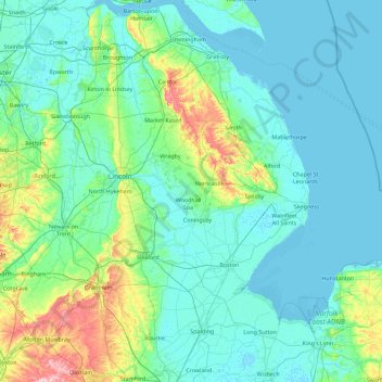
Lincolnshire topographic map
Interactive map
Click on the map to display elevation.
About this map
Name: Lincolnshire topographic map, elevation, terrain.
Location: Lincolnshire, England, United Kingdom (52.64022 -0.95001 53.72446 0.35797)
Average elevation: 26 m
Minimum elevation: -2 m
Maximum elevation: 220 m
Lincolnshire has had a comparatively quiet history, being a rural county which was not heavily industrialised and faced little threat of invasion. In the Roman era Lincoln was a major settlement, called Lindum Colonia. In the fifth century what would become the county was settled by the invading Angles, who established the Kingdom of Lindsey in the north of the region. Lincoln became the centre of a diocese in 1072, and Lincoln Cathedral was built over the following centuries. The late Middle Ages were a particularly prosperous period, when wealth from wool trade facilitated the building of grand churches such as St Botolph's Church, Boston. During the Second World War the relatively flat topography of the county made it an important base for the Royal Air Force, which built several airfields and based two bomber squadrons in the area.
Other topographic maps
Click on a map to view its topography, its elevation and its terrain.
High Wycombe
United Kingdom > England > Buckinghamshire
High Wycombe, Buckinghamshire, England, United Kingdom
Average elevation: 124 m
Ryhill
United Kingdom > England > Wakefield
Ryhill, Wakefield, West Yorkshire, England, United Kingdom
Average elevation: 76 m
Swilla Glen
United Kingdom > England > North Yorkshire > Thornton in Lonsdale
Swilla Glen, Thornton in Lonsdale, North Yorkshire, England, LA6 3JJ, United Kingdom
Average elevation: 204 m
West Lulworth
United Kingdom > England > Dorset
West Lulworth, Dorset, England, United Kingdom
Average elevation: 84 m
Ingleton
United Kingdom > England > North Yorkshire
Ingleton, North Yorkshire, England, United Kingdom
Average elevation: 309 m
Egham
United Kingdom > England > Surrey > Borough of Runnymede
Egham, Borough of Runnymede, Surrey, England, United Kingdom
Average elevation: 25 m
Bradford
Bradford, West Yorkshire, England, United Kingdom
Average elevation: 175 m
Cornwall
United Kingdom > England > Fairy Cross
Cornwall, Broadoak, Fairy Cross, Cornwall, South West England, England, United Kingdom
Average elevation: 49 m
Malvern
United Kingdom > England > Worcestershire > Malvern Hills
Malvern, Malvern Hills, Worcestershire, England, WR14 2HX, United Kingdom
Average elevation: 95 m
Swindon
United Kingdom > England > Swindon
Swindon, England, SN1 1LF, United Kingdom
Average elevation: 108 m
Headley
United Kingdom > England > Surrey > Mole Valley
Headley, Mole Valley, Surrey, England, United Kingdom
Average elevation: 146 m
Birmingham
Birmingham, West Midlands Combined Authority, England, United Kingdom
Average elevation: 138 m
Wakefield
Wakefield, West Yorkshire, England, United Kingdom
Average elevation: 88 m
Bedgebury National Pinetum
United Kingdom > England > Kent > Tunbridge Wells > Kilndown
Bedgebury National Pinetum, Goudhurst, Kilndown, Tunbridge Wells, Kent, England, United Kingdom
Average elevation: 91 m
Knole Park (Deer Park)
United Kingdom > England > Kent > Sevenoaks > Sevenoaks Weald
Knole Park (Deer Park), Sevenoaks Weald, Sevenoaks, Kent, England, United Kingdom
Average elevation: 161 m
Richmond Park
United Kingdom > England > London
Richmond Park, London Borough of Richmond upon Thames, London, Greater London, England, United Kingdom
Average elevation: 26 m
Middlesbrough
United Kingdom > England > Middlesbrough
Middlesbrough, Tees Valley, England, United Kingdom
Average elevation: 26 m
Droitwich Spa
United Kingdom > England > Worcestershire > Wychavon
Droitwich Spa, Wychavon, Worcestershire, England, WR9 8DY, United Kingdom
Average elevation: 49 m
Charlbury
United Kingdom > England > Oxfordshire > West Oxfordshire > Charlbury
Charlbury, West Oxfordshire, Oxfordshire, England, United Kingdom
Average elevation: 132 m
Sledge Green
United Kingdom > England > Worcestershire > Malvern Hills > Pendock
Sledge Green, Pendock, Malvern Hills, Worcestershire, England, WR13 6JP, United Kingdom
Average elevation: 21 m
Hatfield
United Kingdom > England > Hertfordshire > Welwyn Hatfield
Hatfield, Welwyn Hatfield, Hertfordshire, England, United Kingdom
Average elevation: 90 m
Cheddar
United Kingdom > England > Somerset
Cheddar, Somerset, England, United Kingdom
Average elevation: 109 m
Trimpley Green
United Kingdom > England > Worcestershire > Wyre Forest
Trimpley Green, Kidderminster Foreign, Wyre Forest, Worcestershire, England, United Kingdom
Average elevation: 113 m
Cheltenham
United Kingdom > England > Gloucestershire
Cheltenham, Gloucestershire, England, United Kingdom
Average elevation: 109 m
Chapel Brampton
United Kingdom > England > West Northamptonshire
Chapel Brampton, West Northamptonshire, England, NN6 8AF, United Kingdom
Average elevation: 91 m
Slaley
United Kingdom > England > Northumberland
Slaley, Northumberland, North of Tyne, England, United Kingdom
Average elevation: 210 m
Meltham
United Kingdom > England > Kirklees
Meltham, Kirklees, West Yorkshire, England, United Kingdom
Average elevation: 278 m
Rochdale
Rochdale, Greater Manchester, England, United Kingdom
Average elevation: 223 m
Settle
United Kingdom > England > North Yorkshire
Settle, North Yorkshire, England, United Kingdom
Average elevation: 238 m
Swinford
United Kingdom > England > Oxfordshire > Vale of White Horse
Swinford, Vale of White Horse, Oxfordshire, England, OX29 4BZ, United Kingdom
Average elevation: 76 m
Leigh
Leigh, Wigan, Greater Manchester, England, WN7 4LA, United Kingdom
Average elevation: 34 m
Keswick
United Kingdom > England > Cumberland
Keswick, Cumberland, England, United Kingdom
Average elevation: 128 m
Ramsgate
United Kingdom > England > Kent > Thanet
Ramsgate, Broadstairs, Thanet, Kent, England, United Kingdom
Average elevation: 25 m
Pen-y-ghent
United Kingdom > England > North Yorkshire
Pen-y-ghent, North Yorkshire, England, BD24 9PW, United Kingdom
Average elevation: 487 m
Blickling Hall
United Kingdom > England > Norfolk > Broadland > Blickling > Silvergate
Blickling Hall, Blickling Road, Silvergate, Blickling, Broadland, Norfolk, England, NR11 6NF, United Kingdom
Average elevation: 28 m
Appletreewick
United Kingdom > England > North Yorkshire
Appletreewick, North Yorkshire, England, United Kingdom
Average elevation: 348 m
South Cambridgeshire
United Kingdom > England > Cambridgeshire
South Cambridgeshire, Cambridgeshire, Cambridgeshire and Peterborough, England, United Kingdom
Average elevation: 42 m
Felpham
United Kingdom > England > West Sussex > Arun
Felpham, Arun, West Sussex, England, PO22 7PA, United Kingdom
Average elevation: 2 m
Allesley
United Kingdom > England > Coventry
Allesley, Coventry, West Midlands Combined Authority, England, CV5 9GS, United Kingdom
Average elevation: 115 m
North East Lincolnshire
North East Lincolnshire, England, United Kingdom
Average elevation: 23 m
Penistone
United Kingdom > England > Thurlstone
Penistone, Thurlstone, Barnsley, South Yorkshire, England, United Kingdom
Average elevation: 229 m
Benfieldside
United Kingdom > England > County Durham > Consett
Benfieldside, Consett, County Durham, North East, England, DH8 0RW, United Kingdom
Average elevation: 179 m
Crawley
United Kingdom > England > West Sussex
Crawley, West Sussex, England, United Kingdom
Average elevation: 80 m
Hintlesham
United Kingdom > England > Suffolk > Babergh
Hintlesham, Burstall, Babergh, Suffolk, England, United Kingdom
Average elevation: 48 m
Greenhill Park
United Kingdom > England > Derbyshire > Sheffield
Greenhill Park, Lowedges, Sheffield, Derbyshire, South Yorkshire, England, United Kingdom
Average elevation: 179 m
Rounton
United Kingdom > England > Hertfordshire > Watford
Rounton, Watford, Hertfordshire, England, WD17 4DU, United Kingdom
Average elevation: 78 m
Brighton
United Kingdom > England > East Sussex
Brighton, East Sussex, England, BN1 1HH, United Kingdom
Average elevation: 28 m
Shrewsbury
United Kingdom > England > Shropshire
Shrewsbury, Shropshire, England, United Kingdom
Average elevation: 69 m
Chalfont St Giles
United Kingdom > England > Buckinghamshire
Chalfont St Giles, Denham, Gerrards Cross and Chalfonts Community Board, Buckinghamshire, England, United Kingdom
Average elevation: 107 m