
Eustis topographic map
Interactive map
Click on the map to display elevation.
About this map
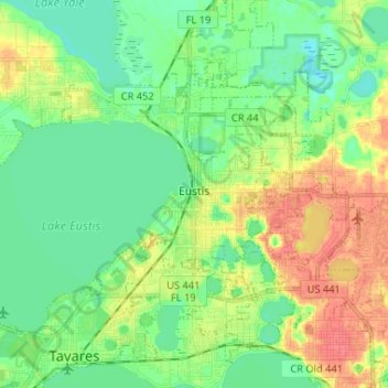
Name: Eustis topographic map, elevation, terrain.
Location: Eustis, Lake County, Florida, United States (28.81103 -81.76213 28.89261 -81.63178)
Average elevation: 25 m
Minimum elevation: 10 m
Maximum elevation: 60 m
Other topographic maps
Click on a map to view its topography, its elevation and its terrain.
Groveland
United States > Florida > Lake County
Groveland, Lake County, Florida, United States
Average elevation: 32 m
Howey-in-the-Hills
United States > Florida > Lake County > Howey-in-the-Hills
Howey-in-the-Hills, Lake County, Florida, 34737, United States
Average elevation: 25 m