
Orange County topographic map
Interactive map
Click on the map to display elevation.
About this map
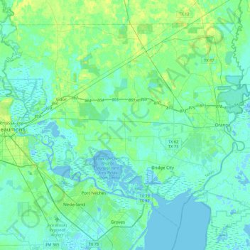
Name: Orange County topographic map, elevation, terrain.
Location: Orange County, Texas, United States (29.93988 -94.11890 30.24266 -93.68843)
Average elevation: 4 m
Minimum elevation: -6 m
Maximum elevation: 17 m
The geography of Orange County varies relatively little, with an elevation that reaches 33 ft (10 m) above sea level at very few points within the county. Orange County is very flat, and its soil is quite sandy, as could be expected in a county along the Gulf of Mexico. (Sandy soil is also common in southern Louisiana, Mississippi, and Alabama, and in western and southern Florida.) Saltwater marshes occur in much of the southeastern part of Orange County that borders the Sabine River. The Piney Woods are in the northern part of the county.
Other topographic maps
Click on a map to view its topography, its elevation and its terrain.
Bridge City
United States > Texas > Orange County > Bridge City
Bridge City, Orange County, Texas, 77611, United States
Average elevation: 3 m