
Make a donation
Gear up for your next adventure:
As an Amazon Associate, this site earns from qualifying purchases at no extra cost to you.
Limerick topographic map
Click on the map to display elevation.
Make a donation
Gear up for your next adventure:
As an Amazon Associate, this site earns from qualifying purchases at no extra cost to you.
Limerick
Limerick's climate is classified as temperate oceanic (Köppen Cfb). Met Éireann maintains a climatological weather station at Shannon Airport, 20 kilometres west of the city in County Clare. Shannon Airport records an average of 977 millimetres of precipitation annually, most of which is rain. Limerick has a mild climate, with the average daily maximum in July of 20 °C (68 °F) and the average daily minimum in January of 3 °C (37 °F). The highest temperature recorded was 32.0 °C (89.6 °F) in June 2018, and the lowest −11.4 °C (11.5 °F) in 2010. Limerick is the cloudiest city in the state, averaging only 1,295 sunshine hours annually, 3.5 hours of sunshine every day. There are on average 62 days of no recordable sunshine, 6 days of thunder, 22 days of hail and 11 days of snow per year. Shannon Airport is located by the ocean at an elevation of 14 metres, so snow is less common at the station than in the city itself.
Make a donation
Gear up for your next adventure:
As an Amazon Associate, this site earns from qualifying purchases at no extra cost to you.
About this map
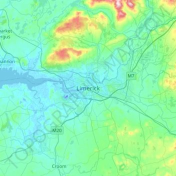
Name: Limerick topographic map, elevation, terrain.
Location: Limerick, County Limerick, Munster, V94 A9NX, Ireland (52.50125 -8.79012 52.82125 -8.47012)
Average elevation: 54 m
Minimum elevation: -26 m
Maximum elevation: 439 m
Ireland trails, hiking, mountain biking, running and outdoor activities
Make a donation
Gear up for your next adventure:
As an Amazon Associate, this site earns from qualifying purchases at no extra cost to you.