
Municipal District of Cobh topographic map
Interactive map
Click on the map to display elevation.
About this map
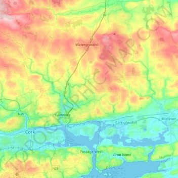
Name: Municipal District of Cobh topographic map, elevation, terrain.
Location: Municipal District of Cobh, County Cork, Munster, Ireland (51.84282 -8.56675 52.06321 -8.18838)
Average elevation: 98 m
Minimum elevation: -3 m
Maximum elevation: 274 m
County Cork trails, hiking, mountain biking, running and outdoor activities
Other topographic maps
Click on a map to view its topography, its elevation and its terrain.