
Chipping Norton topographic map
Interactive map
Click on the map to display elevation.
About this map
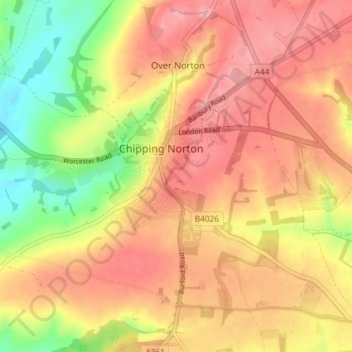
Name: Chipping Norton topographic map, elevation, terrain.
Average elevation: 194 m
Minimum elevation: 128 m
Maximum elevation: 238 m
Other topographic maps
Click on a map to view its topography, its elevation and its terrain.
Charlbury
United Kingdom > England > Oxfordshire > West Oxfordshire > Charlbury
Charlbury, West Oxfordshire, Oxfordshire, England, United Kingdom
Average elevation: 132 m
Shipton-under-Wychwood
United Kingdom > England > Oxfordshire > West Oxfordshire
Shipton-under-Wychwood, West Oxfordshire, Oxfordshire, England, OX7 6DE, United Kingdom
Average elevation: 131 m