
Thank you for supporting this site ❤️
Make a donation
Make a donation
Gear up for your next adventure:
As an Amazon Associate, this site earns from qualifying purchases at no extra cost to you.
Cantón Santa Cruz topographic map
Click on the map to display elevation.
Gear up for your next adventure:
As an Amazon Associate, this site earns from qualifying purchases at no extra cost to you.
Cantón Santa Cruz
Santa Cruz has an area of 1,312.27 km² and a mean elevation of 39 metres.
Thank you for supporting this site ❤️
Make a donation
Make a donation
Gear up for your next adventure:
As an Amazon Associate, this site earns from qualifying purchases at no extra cost to you.
About this map
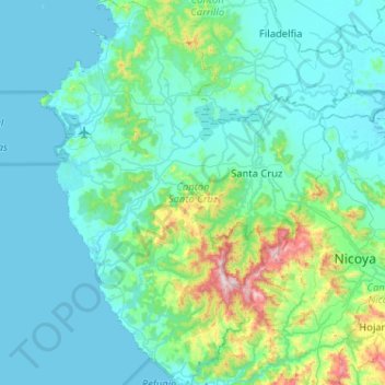
Name: Cantón Santa Cruz topographic map, elevation, terrain.
Location: Cantón Santa Cruz, Provincia Guanacaste, Costa Rica (9.98293 -85.87576 10.48859 -85.40579)
Average elevation: 118 m
Minimum elevation: 0 m
Maximum elevation: 959 m
Thank you for supporting this site ❤️
Make a donation
Make a donation
Gear up for your next adventure:
As an Amazon Associate, this site earns from qualifying purchases at no extra cost to you.