
Make a donation
Gear up for your next adventure:
As an Amazon Associate, this site earns from qualifying purchases at no extra cost to you.
Cox's Bazar topographic map
Click on the map to display elevation.
Make a donation
Gear up for your next adventure:
As an Amazon Associate, this site earns from qualifying purchases at no extra cost to you.
Cox's Bazar
Cox's Bazar lies on a coastal plain in the southeastern corner of Bangladesh. From above, the plain appears to bulge out into the Bay of Bengal. Along the shore is an extensive area of beach and dunes. Most of the city is built on a floodplain that is lower in elevation than the dunes, making it more susceptible to flooding due to cyclones and storm surges. The Cox's Bazar coastal plain was formed after the sea reached its present level around 6,500 years ago, with the area of the current floodplain originally forming a sediment sink that has since been gradually filled in by the Bakkhali river as well as smaller streams coming down from the hills.
Make a donation
Gear up for your next adventure:
As an Amazon Associate, this site earns from qualifying purchases at no extra cost to you.
About this map
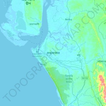
Name: Cox's Bazar topographic map, elevation, terrain.
Average elevation: 13 m
Minimum elevation: -4 m
Maximum elevation: 223 m
Make a donation
Gear up for your next adventure:
As an Amazon Associate, this site earns from qualifying purchases at no extra cost to you.