
Central Kalimantan topographic map
Interactive map
Click on the map to display elevation.
About this map
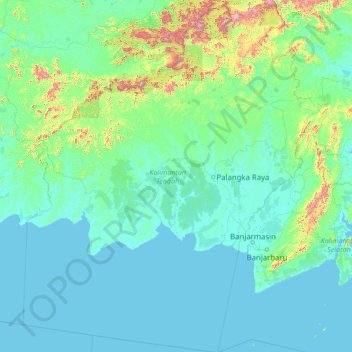
Name: Central Kalimantan topographic map, elevation, terrain.
Location: Central Kalimantan, Indonesia (-5.18827 110.67955 0.79541 115.84880)
Average elevation: 100 m
Minimum elevation: -1 m
Maximum elevation: 2,127 m
Other topographic maps
Click on a map to view its topography, its elevation and its terrain.
Muara Joloi I
Indonesia > Central Kalimantan > Muara Joloi I
Muara Joloi I, Central Kalimantan, Indonesia
Average elevation: 142 m
Seruyan River
Indonesia > Central Kalimantan
Seruyan River, Central Kalimantan, Indonesia
Average elevation: 148 m
Palangka Raya
Indonesia > Central Kalimantan > Palangka Raya
Palangka Raya, Central Kalimantan, 73112, Indonesia
Average elevation: 10 m
Tandjung Puting
Indonesia > Central Kalimantan
Tandjung Puting, Central Kalimantan, Indonesia
Average elevation: 1 m