
Macquarie Island topographic map
Interactive map
Click on the map to display elevation.
Macquarie Island
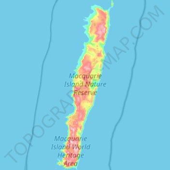
Macquarie Island is about 34 km (21 mi) long and 5 km (3 mi) wide, with an area of 128 km2 (49 sq mi). The island consists of plateaus at north and south ends, each of 150–200 m (490–660 ft) elevation, joined by a low, narrow isthmus. The high points include Mount Elder on the north-east coastal ridge at 385 m (1,263 ft), and Mounts Hamilton and Fletcher in the south at 410 m (1,345 ft). The island is almost equidistant between the island of Tasmania and the Antarctic continent's Anderson Peninsula (about 1,500 km (930 mi) to either point). In addition, Macquarie Island is about 630 km (390 mi) south-east of Auckland Island, and 1,300 km (810 mi) north of the Balleny Islands.
About this map
Name: Macquarie Island topographic map, elevation, terrain.
Average elevation: 20 m
Minimum elevation: 0 m
Maximum elevation: 395 m