
Solukhumbu topographic map
Interactive map
Click on the map to display elevation.
About this map
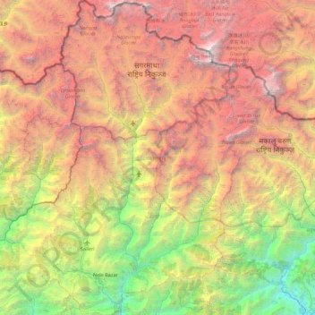
Name: Solukhumbu topographic map, elevation, terrain.
Location: Solukhumbu, Province #1, Nepal (27.33820 86.35572 28.11375 87.00996)
Average elevation: 3,997 m
Minimum elevation: 299 m
Maximum elevation: 8,716 m
Solukhumbu is a Himalayan district of Province No. 1 of Nepal, situated on the north-west corner of province. It is one out of 3 Himalayan districts of Province No. 1. Total area of district is 3,312 square kilometres (1,279 sq mi). It is situated between Lat. 27°20'39" to 28°6'24" North and Long. 86°0'21" to 87°0'1" East. The highest elevation of district is 8,848 metres (29,029 ft) (Mount Everest) and the lowest elevation is 600 metres (2,000 ft) (Tuintar) above sea level. The district is surrounded by Sankhuwasabha in east, Bhojpur in south-east, Khotang and Okhaldhunga in south, Bagmati Pradesh in west and Tibet (China) in north.
Other topographic maps
Click on a map to view its topography, its elevation and its terrain.
Mount Everest
Nepal > Koshi Province > Solukhumbu
Mount Everest, Khumbupasanglahmu, Solukhumbu, Koshi Province, Nepal
Average elevation: 7,847 m
Kachankawal
Nepal > Koshi Province > Jhapa
Kachankawal, Jhapa, Koshi Province, Nepal
Average elevation: 72 m
Chandrakot
Nepal > Lumbini Province > Gulmi
Chandrakot, Gulmi, Lumbini Province, Nepal
Average elevation: 1,592 m
Sarketari Baandh/ Risk And Hazards/ Flood
Nepal > Dhading > Dhading Besi
Sarketari Baandh/ Risk And Hazards/ Flood, Nilkantha Municipality Ward No. 4, Dhading Besi, Nilakantha, Dhading, Bagmati Pradesh, Nepal
Average elevation: 933 m
Mount Everest
Nepal > Koshi Province > Solukhumbu
Mount Everest, Khumbupasanglahmu, Solukhumbu, Koshi Province, Nepal
Average elevation: 7,850 m
Mount Everest
Nepal > Eastern Development Region > Khumjung
Mount Everest, Khumjung, Khumbupasanglahmu, Solukhumbu, Province #1, Nepal
Average elevation: 7,841 m
Kathmandu
Nepal > Central Development Region > Kathmandu
Kathmandu, Bagmati, Central Development Region, Nepal
Average elevation: 1,331 m
Chilime Khola
Chilime Khola, Briddhim, Gosaikunda, Rasuwa, Bagmati Pradesh, Nepal
Average elevation: 1,871 m
Tara
Nepal > Western Development Region > Tara
Tara, Baglung, Dhaulagiri, Western Development Region, Nepal
Average elevation: 2,315 m
Jomsom
Nepal > Western Development Region > Jomsom
Jomsom, Mustang, Dhaulagiri, Western Development Region, Nepal
Average elevation: 3,031 m
Ghandruk
Nepal > Western Development Region > Ghandruk
Ghandruk, Kaski, Gandaki, Western Development Region, Nepal
Average elevation: 3,527 m
Devadaha
Nepal > Western Development Region > Devadaha
Devadaha, Rupandehi, Lumbini, Western Development Region, Nepal
Average elevation: 295 m
Dharapani
Nepal > Western Development Region > Dharapani
Dharapani, Arghakhanchi, Lumbini, Western Development Region, Nepal
Average elevation: 1,195 m
Himalayas
Nepal > Solukhumbu > Khumjung
Himalayas, Khumjung, Khumbupasanglahmu, Solukhumbu, Province #1, Nepal
Average elevation: 7,555 m
Lhotse Shar
Nepal > Eastern Development Region > Khumjung
Lhotse Shar, Khumjung, Solukhumbu, Sagarmatha, Eastern Development Region, Nepal
Average elevation: 7,153 m
Darling
Nepal > Western Development Region > Darling
Darling, Gulmi, Lumbini, Western Development Region, Nepal
Average elevation: 1,681 m
Mahakali
Nepal > Far-Western Development Region
Mahakali, Far-Western Development Region, Nepal
Average elevation: 1,733 m
Annapurna II
Nepal > Western Development Region > Parche
Annapurna II, Parche, Kaski, Gandaki, Western Development Region, Nepal
Average elevation: 7,052 m
Mechi
Nepal > Eastern Development Region
Mechi, Eastern Development Region, Nepal
Average elevation: 1,902 m
Annapurna I
Nepal > Western Development Region > Ghandruk
Annapurna I, Ghandruk, Kaski, Gandaki, Western Development Region, Nepal
Average elevation: 7,127 m
Koshi
Nepal > Eastern Development Region
Koshi, Eastern Development Region, Nepal
Average elevation: 1,899 m
Mahalangur Himal
Nepal > Eastern Development Region > Makalu
Mahalangur Himal, Makalu, Sankhuwasabha, Koshi, Eastern Development Region, Nepal
Average elevation: 4,695 m
Dhaulagiri
Nepal > Western Development Region > Mudi
Dhaulagiri, Mudi, Myagdi, Dhaulagiri, Western Development Region, Nepal
Average elevation: 7,321 m
Gandaki
Nepal > Western Development Region
Gandaki, Western Development Region, Nepal
Average elevation: 2,842 m
Island Peak
Nepal > Eastern Development Region > Khumjung
Island Peak, Khumjung, Solukhumbu, Sagarmatha, Eastern Development Region, Nepal
Average elevation: 5,461 m
Khumbu Glacier
Nepal > Eastern Development Region > Khumjung > Khumjung
Khumbu Glacier, Khumjung, Solukhumbu, Sagarmatha, Eastern Development Region, Nepal
Average elevation: 6,297 m
Ghaghara River
Nepal > Mid-Western Development Region
Ghaghara River, Dailekh, Bheri, Mid-Western Development Region, 271833, Nepal
Average elevation: 1,522 m
Bagmati
Nepal > Central Development Region
Bagmati, Central Development Region, Nepal
Average elevation: 2,279 m
Chilime Khola
Nepal > Central Development Region
Chilime Khola, Rasuwa, Bagmati, Central Development Region, Nepal
Average elevation: 2,388 m