
Erlangen topographic map
Interactive map
Click on the map to display elevation.
About this map
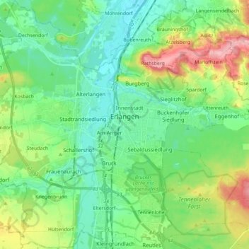
Name: Erlangen topographic map, elevation, terrain.
Location: Erlangen, Bavaria, Germany (49.53277 10.91536 49.64558 11.05360)
Average elevation: 302 m
Minimum elevation: 264 m
Maximum elevation: 395 m
In 1435 the church, which had been the daughter church of St. Martin in Forchheim up until this point, was elevated to its own parish. The main task of the Erlangen priest was the pastoral care in the city of Erlangen and the St. Martin's Chapel on the Martinsbühl, which was now named for the first time. Furthermore, the document of elevation determines the pastoral care of the surrounding villages of Bubenreuth, Bräuningshof, Marloffstein, Spardorf and Sieglitzhof, whose inhabitants visited the chapel of the Virgin Mary, were pastorally cared for from this chapel and were provided with the sacraments. This addition confirms that there was at least one vicar at the Frauenkirche (Church of Our Lady) before it was elevated to a parish church. The ecclesiastical life was accordingly pronounced and varied at the time. In addition to the parish priest, there were two vicars for the early and middle mass. Whether the financially very badly equipped Mass Beneficiaries were always occupied is not known. With the introduction of the Reformation by Margrave George the Pious in 1528 in Erlangen, the Catholic life of the church was extinguished completely for many years. Only few things from this time remain today: five figures of saints from the former Marienkirche, which today are placed on the northern altar wall in the Altstädter Trinity Church, a measuring cup and the equestrian statue of Saint Martin, which is exhibited annually on St. Martin's Day in the Martinsbühler church.