
West Clare Municipal District topographic map
Interactive map
Click on the map to display elevation.
About this map
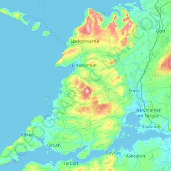
Name: West Clare Municipal District topographic map, elevation, terrain.
Location: West Clare Municipal District, County Clare, Munster, Ireland (52.55447 -9.93876 53.16891 -8.88244)
Average elevation: 37 m
Minimum elevation: -2 m
Maximum elevation: 386 m
County Clare trails, hiking, mountain biking, running and outdoor activities
Other topographic maps
Click on a map to view its topography, its elevation and its terrain.