
Galveston County topographic map
Interactive map
Click on the map to display elevation.
About this map
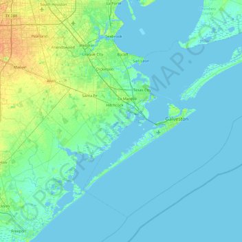
Name: Galveston County topographic map, elevation, terrain.
Location: Galveston County, Texas, United States (28.99634 -95.23308 29.59826 -94.36628)
Average elevation: 4 m
Minimum elevation: -3 m
Maximum elevation: 23 m
Other topographic maps
Click on a map to view its topography, its elevation and its terrain.
Bolivar Peninsula
United States > Texas > Galveston County > Bolivar Peninsula
Bolivar Peninsula, Galveston County, Texas, 77652, United States
Average elevation: 1 m
Port Bolivar
United States > Texas > Galveston County > Port Bolivar
Port Bolivar, Galveston County, Texas, United States
Average elevation: 1 m
Crystal Beach
United States > Texas > Galveston County > Crystal Beach
Crystal Beach, Galveston County, Texas, 77652, United States
Average elevation: 1 m
Goat Island
United States > Texas > Galveston County
Goat Island, Galveston County, Texas, United States
Average elevation: 1 m