
Madison County topographic map
Interactive map
Click on the map to display elevation.
About this map
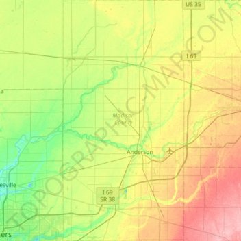
Name: Madison County topographic map, elevation, terrain.
Location: Madison County, Indiana, United States (39.94364 -85.86302 40.37968 -85.57539)
Average elevation: 270 m
Minimum elevation: 230 m
Maximum elevation: 336 m
Other topographic maps
Click on a map to view its topography, its elevation and its terrain.
Drexel Gardens
United States > Indiana > Marion County > Indianapolis
Drexel Gardens, Indianapolis, Marion County, Indiana, 46241, United States
Average elevation: 226 m
Greencastle
United States > Indiana > Putnam County > Greencastle
Greencastle, Putnam County, Indiana, 46135-1649, United States
Average elevation: 235 m
Dyer
United States > Indiana > Lake County > Dyer
Dyer, Lake County, Indiana, 46311, United States
Average elevation: 196 m