
Ankeny topographic map
Interactive map
Click on the map to display elevation.
About this map
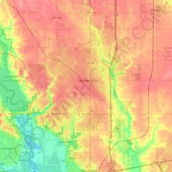
Name: Ankeny topographic map, elevation, terrain.
Location: Ankeny, Polk County, Iowa, United States (41.65213 -93.67277 41.78408 -93.54144)
Average elevation: 283 m
Minimum elevation: 237 m
Maximum elevation: 309 m
Like most of Polk County, Ankeny exists at the bottom area of the Des Moines Lobe, a topographical landscape area, in an area known as the Bemis Advance. The Lobe was formed during the Wisconsin glaciation leaving significant deposits resulting in an area with low relief.