
Falls Creek topographic map
Interactive map
Click on the map to display elevation.
About this map
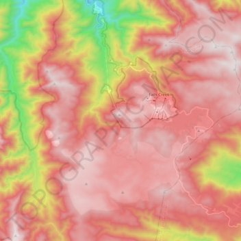
Name: Falls Creek topographic map, elevation, terrain.
Location: Falls Creek, Victoria, 3699, Australia (-36.94013 147.14335 -36.81784 147.34558)
Average elevation: 1,459 m
Minimum elevation: 629 m
Maximum elevation: 1,892 m
The Falls Creek Alpine Resort is an alpine ski resort in the Hume region in northeastern Victoria, Australia. It is located in the Alpine National Park in the Victorian Alps, approximately 350 kilometres (220 miles) by road from Melbourne, with the nearest town being Mount Beauty, which is approximately 30 km (20 mi) away. The resort lies between an elevation of 1,210 and 1,830 m (3,970 and 6,004 ft) above sea level, with the highest lifted point at 1,780 m (5,840 ft). Skiing is possible on the nearby peak of Mount McKay at 1,842 m (6,043 ft), accessed by snowcat from the resort.
Other topographic maps
Click on a map to view its topography, its elevation and its terrain.
Mount Dandenong
Australia > Victoria > Melbourne
Mount Dandenong, Melbourne, Shire of Yarra Ranges, Victoria, 3767, Australia
Average elevation: 389 m
You Yangs Regional Park
Australia > Victoria > Little River
You Yangs Regional Park, Little River, City of Greater Geelong, Victoria, 3212, Australia
Average elevation: 97 m
Shire of Macedon Ranges
Shire of Macedon Ranges, Victoria, Australia
Average elevation: 464 m
Dandenong Ranges
Australia > Victoria > Melbourne
Dandenong Ranges, Melbourne, Shire of Yarra Ranges, Victoria, 3767, Australia
Average elevation: 456 m
Soldiers Hill
Australia > Victoria > Ballarat
Soldiers Hill, Ballarat, City of Ballarat, Victoria, 3350, Australia
Average elevation: 449 m
City of Greater Geelong
City of Greater Geelong, Victoria, Australia
Average elevation: 77 m
Mornington District
Australia > Victoria > Melbourne
Mornington District, Melbourne, Shire of Mornington Peninsula, Victoria, Australia
Average elevation: 50 m
Mount Cobbler
Mount Cobbler, Rural City of Wangaratta, Victoria, Australia
Average elevation: 1,226 m
Narre Warren North Retarding Basin (Melbourne Water)
Australia > Victoria > Melbourne
Narre Warren North Retarding Basin (Melbourne Water), Narre Warren North, Melbourne, City of Casey, Victoria, 3804, Australia
Average elevation: 76 m
Drummartin
Drummartin, City of Greater Bendigo, Victoria, Australia
Average elevation: 120 m
Garfield North
Garfield North, Shire of Cardinia, Victoria, Australia
Average elevation: 137 m
Castlemaine
Australia > Victoria > Castlemaine
Castlemaine, Shire of Mount Alexander, Victoria, 3450, Australia
Average elevation: 319 m
Mount Buller
Australia > Victoria > Mt Buller Village
Mount Buller, Mt Buller Village, Hume, Victoria, Australia
Average elevation: 1,236 m
Sandringham District
Sandringham District, Joan Lane, Moorabbin, City of Kingston, Victoria, 3189, Australia
Average elevation: 24 m
Lysterfield
Lysterfield, Shire of Yarra Ranges, Victoria, Australia
Average elevation: 128 m
Thomastown District
Australia > Victoria > Melbourne
Thomastown District, Melbourne, City of Whittlesea, Victoria, Australia
Average elevation: 158 m
City of Boroondara
City of Boroondara, Victoria, Australia
Average elevation: 53 m
Rural City of Mildura
Rural City of Mildura, Loddon Mallee, Victoria, Australia
Average elevation: 65 m
Willow Grove
Australia > Victoria > Willow Grove
Willow Grove, Shire of Baw Baw, Gippsland, Victoria, Australia
Average elevation: 145 m
Broadmeadows
Australia > Victoria > Melbourne
Broadmeadows, Melbourne, City of Hume, Victoria, 3047, Australia
Average elevation: 118 m
Springvale
Springvale, City of Greater Dandenong, Victoria, 3171, Australia
Average elevation: 59 m
Mount Dawson
Mount Dawson, Shire of East Gippsland, Gippsland, Victoria, Australia
Average elevation: 435 m
Macedon District
Australia > Victoria > Carlsruhe
Macedon District, Thomsons Lane, Tylden, Carlsruhe, Shire of Macedon Ranges, Loddon Mallee, Victoria, Australia
Average elevation: 430 m
Willow Grove
Australia > Victoria > Willow Grove
Willow Grove, Shire of Baw Baw, Gippsland, Victoria, Australia
Average elevation: 150 m
Hobsons Bay
Hobsons Bay, Spirit of Tasmania vehicle access, Beacon Cove, Port Melbourne, City of Port Phillip, Victoria, 3207, Australia
Average elevation: 2 m
Mount Strickland
Mount Strickland, Shire of Murrindindi, Hume, Victoria, Australia
Average elevation: 868 m
Lara District
Australia > Victoria > Geelong
Lara District, Shearers Lane, Lara, Geelong, City of Greater Geelong, Barwon South West, Victoria, 3212, Australia
Average elevation: 94 m
Wilsons Promontory National Park
Wilsons Promontory National Park, Vereker Outlook, Wilsons Promontory, Shire of South Gippsland, Gippsland, Victoria, Australia
Average elevation: 32 m
Wingan River
Wingan River, Shire of East Gippsland, Gippsland, Victoria, Australia
Average elevation: 131 m
Badger Creek
Australia > Victoria > Healesville
Badger Creek, Healesville, Shire of Yarra Ranges, Victoria, Australia
Average elevation: 255 m
Mount Feathertop
Mount Feathertop, Alpine Shire, Hume, Victoria, Australia
Average elevation: 1,533 m