
Long Island topographic map
Interactive map
Click on the map to display elevation.
About this map
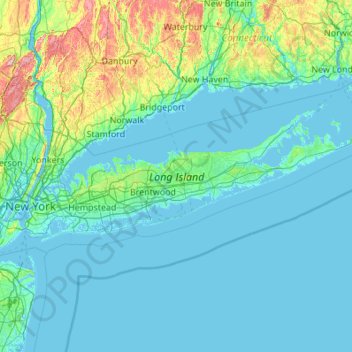
Name: Long Island topographic map, elevation, terrain.
Location: Long Island, New York, United States (40.54190 -74.04197 41.16116 -71.85627)
Average elevation: 42 m
Minimum elevation: -5 m
Maximum elevation: 498 m
The land to the south of this moraine to the South Shore is the outwash plain of the last glacier. One part of the outwash plain was known as the Hempstead Plains, and this land contained one of the few natural prairies to exist east of the Appalachian Mountains. The glaciers melted and receded to the north, resulting in the difference between the topography of the North Shore beaches and the South Shore beaches. The North Shore beaches are rocky from the remaining glacial debris, while the South Shore's are crisp, clear, outwash sand. Jayne's Hill, at 401 feet (122 m), within Suffolk County near its border with Nassau County, is the highest hill along either moraine; another well-known summit is Bald Hill in Brookhaven Town, not far from its geographical center at Middle Island. The glaciers also formed Lake Ronkonkoma in Suffolk County and Lake Success in Nassau County, each a deep kettle lake.
Other topographic maps
Click on a map to view its topography, its elevation and its terrain.
The Bronx
United States > New York > New York
The Bronx, New York, United States
Average elevation: 23 m
City of Albany
United States > New York > Albany County
City of Albany, Albany County, New York, United States
Average elevation: 68 m
Town of Wilton
United States > New York > Saratoga County
Town of Wilton, Saratoga County, New York, 12831, United States
Average elevation: 140 m
Village of Black River
United States > New York > Jefferson County
Village of Black River, Town of Le Ray, Jefferson County, New York, United States
Average elevation: 193 m
Mount Vision
United States > New York > Otsego County
Mount Vision, Town of Laurens, Otsego County, New York, United States
Average elevation: 415 m
Shirley
United States > New York > Suffolk County > Town of Brookhaven
Shirley, Town of Brookhaven, Suffolk County, New York, 11967, United States
Average elevation: 11 m
Uneeda Beach
United States > New York > Niagara County
Uneeda Beach, Town of Porter, Niagara County, New York, United States
Average elevation: 79 m
Newtown Creek
United States > New York > New York
Newtown Creek, Queens County, New York, United States
Average elevation: 8 m
Birch Island
United States > New York > Saint Lawrence County
Birch Island, Town of Clifton, Saint Lawrence County, New York, 12927, United States
Average elevation: 469 m
Jenkinstown
United States > New York > Ulster County > Town of Gardiner
Jenkinstown, Town of Gardiner, Ulster County, New York, 12548, United States
Average elevation: 116 m
West Fulton
United States > New York > Schoharie County > West Fulton
West Fulton, Town of Fulton, Schoharie County, New York, 12194, United States
Average elevation: 497 m
Town of Hurley
United States > New York > Ulster County > Town of Hurley
Town of Hurley, Ulster County, New York, United States
Average elevation: 123 m
East Moriches
United States > New York > Suffolk County > Town of Brookhaven > East Moriches
East Moriches, Town of Brookhaven, Suffolk County, New York, 11940, United States
Average elevation: 9 m
Valhalla
United States > New York > Westchester County > Town of Mount Pleasant > Valhalla
Valhalla, Town of Mount Pleasant, Westchester County, New York, 10595, United States
Average elevation: 110 m
Galway
United States > New York > Saratoga County > Galway
Galway, Village of Galway, Town of Galway, Saratoga County, New York, 12074, United States
Average elevation: 258 m
Syracuse
United States > New York > Syracuse
Syracuse, Onondaga County, New York, United States
Average elevation: 172 m
Barkersville
United States > New York > Saratoga County > Barkersville
Barkersville, Town of Providence, Saratoga County, New York, 12074, United States
Average elevation: 371 m
Woodstock
United States > New York > Woodstock
Woodstock, Town of Woodstock, Ulster County, New York, 12498, United States
Average elevation: 248 m
Uniondale
United States > New York > Hempstead > Uniondale
Uniondale, Hempstead, Nassau County, New York, 11553, United States
Average elevation: 20 m
Town of Ulster
Town of Ulster, Ulster County, New York, 12449, United States
Average elevation: 79 m
City of New Rochelle
United States > New York > Westchester County
City of New Rochelle, Westchester County, New York, United States
Average elevation: 31 m
City of Rochester
United States > New York > Monroe County
City of Rochester, Monroe County, New York, United States
Average elevation: 129 m
Brooklyn
United States > New York > New York
Brooklyn, Kings County, New York, United States
Average elevation: 9 m
New York County
United States > New York > New York
New York County, New York, United States
Average elevation: 16 m
Manhattan
United States > New York > New York County > New York
Manhattan, New York County, New York, United States
Average elevation: 16 m
Croghan
United States > New York > Croghan
Croghan, Lewis County, New York, United States
Average elevation: 254 m