
Loughrea Municipal District topographic map
Interactive map
Click on the map to display elevation.
About this map
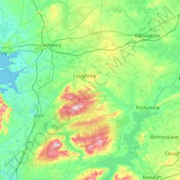
Name: Loughrea Municipal District topographic map, elevation, terrain.
Location: Loughrea Municipal District, County Galway, Connacht, Ireland (52.96818 -9.05179 53.33349 -8.06208)
Average elevation: 69 m
Minimum elevation: -1 m
Maximum elevation: 392 m
County Galway trails, hiking, mountain biking, running and outdoor activities
Other topographic maps
Click on a map to view its topography, its elevation and its terrain.