
Wheeler County topographic map
Interactive map
Click on the map to display elevation.
About this map
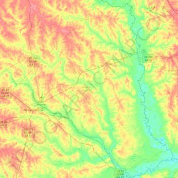
Name: Wheeler County topographic map, elevation, terrain.
Location: Wheeler County, Georgia, USA (31.91919 -82.93991 32.30917 -82.53926)
Average elevation: 62 m
Minimum elevation: 22 m
Maximum elevation: 108 m
Other topographic maps
Click on a map to view its topography, its elevation and its terrain.
Arabia Mountain
USA > Georgia > Stonecrest
Arabia Mountain, Stonecrest, DeKalb County, Georgia, 30058-8829, USA
Average elevation: 255 m
Ferrell Crossroads
USA > Georgia > Ferrell Crossroads
Ferrell Crossroads, Early County, Georgia, USA
Average elevation: 94 m