
Ticino topographic map
Interactive map
Click on the map to display elevation.
Ticino
Although it includes the lowest point of Switzerland (Lake Maggiore) as well as its lowest town (Ascona), the topography of Ticino is extremely rugged, as it is the canton with the fourth largest elevation difference. It lies essentially within the Alps, in particular the Lepontine Alps, the Saint-Gotthard Massif and the Lugano Prealps. The longest and deepest valleys are those of the Ticino, Verzasca and Maggia. The two highest mountains are the Rheinwaldhorn and the Basòdino. Other notable mountains are Pizzo Rotondo (highest of the Gotthard Massif), Pizzo Campo Tencia (highest fully within the canton), Monte Generoso (highest south of Lake Lugano) and Monte Tamaro (most prominent of the canton). For an exhaustive list, see list of mountains of Ticino.
About this map
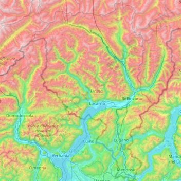
Name: Ticino topographic map, elevation, terrain.
Location: Ticino, Switzerland (45.81797 8.38204 46.63249 9.15970)
Average elevation: 1,389 m
Minimum elevation: 187 m
Maximum elevation: 3,546 m
Other topographic maps
Click on a map to view its topography, its elevation and its terrain.
Braggio
Switzerland > Grisons > Moësa > Calanca > Arvigo
The former municipality is located in the Calanca sub-district of the Moesa district on the left side of the Val Calanca. It is on a high meadow at an elevation of 1,320 m (4,330 ft) and can only be reached via a cable car (since 1961) or a narrow footpath.
Average elevation: 1,521 m
Kiental
Switzerland > Bern > Frutigen-Niedersimmental administrative district > Reichenbach im Kandertal
Average elevation: 1,363 m
Geneva
The altitude of Geneva is 373.6 m (1,225.7 ft) and corresponds to the altitude of the largest of the Pierres du Niton, two large rocks emerging from the lake which date from the last ice age. This rock was chosen by General Guillaume Henri Dufour as the reference point for surveying in Switzerland. The second…
Average elevation: 608 m