
South Korea topographic map
Interactive map
Click on the map to display elevation.
About this map
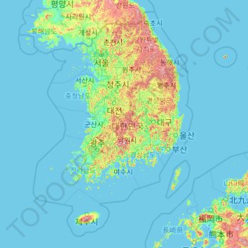
Name: South Korea topographic map, elevation, terrain.
Location: South Korea (32.91046 124.37273 38.61772 132.14678)
Average elevation: 79 m
Minimum elevation: -3 m
Maximum elevation: 1,694 m
Other topographic maps
Click on a map to view its topography, its elevation and its terrain.
Ireland
Ireland
Average elevation: 44 m
Bangladesh
Bangladesh
Average elevation: 161 m
Chasiv Yar
Chasiv Yar, Chasiv Yar Urban Hromada, Bakhmut Raion, Donetsk Oblast, 84551-84556, Ukraine
Average elevation: 213 m
Taiwan
Taiwan > Taiwan Province > Xinyi Township
Taiwan, Xinyi Township, Nantou County, Taiwan Province, Taiwan
Average elevation: 196 m
Croatia
Croatia
Average elevation: 323 m
Cork
Ireland > County Cork > Cork
Cork, County Cork, Munster, T12 T997, Ireland
Average elevation: 94 m
Victorville
United States > California > San Bernardino County
Victorville, San Bernardino County, California, United States
Average elevation: 920 m
Ballyseedy Wood
Ballyseedy Wood, Ballyseedy ED, Tralee Municipal District, County Kerry, Munster, Ireland
Average elevation: 20 m
El Salvador
El Salvador
Average elevation: 484 m
Dromore West
Dromore West, Ballymote-Tubbercurry Municipal District, County Sligo, Connacht, Ireland
Average elevation: 51 m
Czechia
Czechia
Average elevation: 369 m
Monterey County
Monterey County, California, United States
Average elevation: 282 m
Valencia
Spain > Valencian Community > Comarca de València
Valencia, Comarca de València, Valencia, Valencian Community, Spain
Average elevation: 37 m
Johnstown
Johnstown, The Municipal District of Naas, County Kildare, Leinster, W91 Y3CP, Ireland
Average elevation: 97 m
Ballybrack
Ballybrack, Moville ED, Inishowen Municipal District, County Donegal, Ireland
Average elevation: 147 m
Conaghy
Conaghy, Killeevan ED, Ballybay-Clones Municipal District, County Monaghan, Ulster, Ireland
Average elevation: 67 m
Tooele County
United States of America > Utah
Tooele County, Utah, United States of America
Average elevation: 1,462 m
High Wycombe
United Kingdom > England > Buckinghamshire
High Wycombe, Buckinghamshire, England, United Kingdom
Average elevation: 124 m
Cloonkeenkerrill
Cloonkeenkerrill, Colmanstown ED, Ballinasloe Municipal District, County Galway, Connacht, Ireland
Average elevation: 88 m
Colmanstown
Colmanstown, Killofin ED, West Clare Municipal District, County Clare, Munster, Ireland
Average elevation: 24 m
Europe
Europe
Average elevation: 223 m
Madagascar
Madagascar
Average elevation: 139 m
Gort
Gort, Loughrea Municipal District, County Galway, Connacht, H91 R5F9, Ireland
Average elevation: 27 m
El Dorado County
El Dorado County, California, United States
Average elevation: 1,286 m
Morristown
Morristown, Rathmore ED, The Municipal District of Naas, County Kildare, Leinster, Ireland
Average elevation: 113 m
Galway City
Galway, Galway City, County Galway, Connacht, H91 YD86, Ireland
Average elevation: 26 m
Markaryds kommun
Markaryds kommun, Kronoberg County, Sweden
Average elevation: 137 m
Kilkenny
Kilkenny, The Municipal District of Kilkenny City, County Kilkenny, Leinster, Ireland
Average elevation: 61 m
Nasugbu
Nasugbu, Batangas, Calabarzon, 4231, Philippines
Average elevation: 71 m
San Bernardino County
San Bernardino County, California, United States
Average elevation: 763 m
Latvia
Latvia
Average elevation: 72 m
General Mamerto Natividad
General Mamerto Natividad, Nueva Ecija, Central Luzon, 3125, Philippines
Average elevation: 61 m
Bad Krozingen
Germany > Baden-Württemberg > Landkreis Breisgau-Hochschwarzwald
Bad Krozingen, VVG der Stadt Bad Krozingen, Landkreis Breisgau-Hochschwarzwald, Baden-Württemberg, Germany
Average elevation: 243 m
West Lulworth
United Kingdom > England > Dorset
West Lulworth, Dorset, England, United Kingdom
Average elevation: 84 m
Morristown
United States > New Jersey > Morris County
Morristown, Morris County, New Jersey, 07960, United States
Average elevation: 123 m
Helena
United States > Montana > Lewis and Clark County
Helena, Lewis and Clark County, Montana, United States
Average elevation: 1,296 m