
Atlanta topographic map
Interactive map
Click on the map to display elevation.
Atlanta
Atlanta (/ætˈlæntə/ at-LAN-tə) is the capital and most populous city of the U.S. state of Georgia. It is the seat of Fulton County, the most populous county in Georgia, although a portion of the city extends into neighboring DeKalb County. With a population of 498,715 living within the city limits, it is the eighth most populous city in the Southeast and 38th most populous city in the United States according to the 2020 U.S. census. It is the core of the much larger Atlanta metropolitan area, which is home to more than 6.1 million people, making it the eighth-largest metropolitan area in the United States. Situated among the foothills of the Appalachian Mountains at an elevation of just over 1,000 feet (300 m) above sea level, it features unique topography that includes rolling hills, lush greenery, and the most dense urban tree coverage of any major city in the United States.
About this map
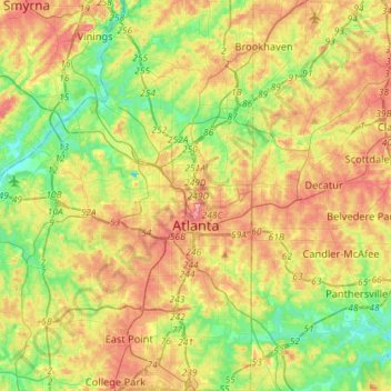
Name: Atlanta topographic map, elevation, terrain.
Location: Atlanta, Fulton County, Georgia, United States (33.64781 -84.55107 33.88682 -84.28956)
Average elevation: 284 m
Minimum elevation: 225 m
Maximum elevation: 358 m
Other topographic maps
Click on a map to view its topography, its elevation and its terrain.
Atlanta
United States > Georgia > Fulton County
Atlanta (/ætˈlæntə/ at-LAN-tə) is the capital and most populous city of the U.S. state of Georgia. It lies primarily within Fulton County (for which it serves as county seat), with about 10% of the city lying within neighboring DeKalb County. With a population of 498,715 living within the city limits, it…
Average elevation: 285 m