
Quito topographic map
Interactive map
Click on the map to display elevation.
About this map
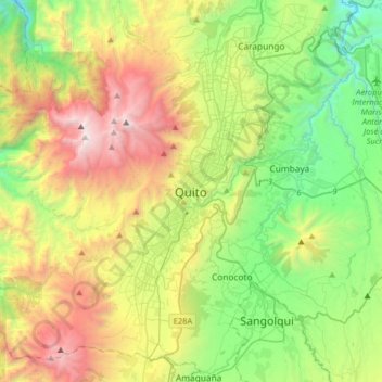
Name: Quito topographic map, elevation, terrain.
Location: Quito, Quito Canton, Pichincha, 170130, Ecuador (-0.38016 -78.67233 -0.06016 -78.35233)
Average elevation: 2,930 m
Minimum elevation: 1,897 m
Maximum elevation: 4,737 m
Quito (/ˈkiːtoʊ/; Spanish pronunciation: (listen); Quechua: Kitu; formally San Francisco de Quito) is the capital of Ecuador, the country's most populous city, and at an elevation of 2,850 metres (9,350 ft) above sea level, it is the second highest official capital city in the world, after La Paz, and the one which is closest to the equator. It is located in the Guayllabamba river basin, on the eastern slopes of Pichincha, an active stratovolcano in the Andes Mountains.