Lauterbrunnen topographic map
Interactive map
Click on the map to display elevation.
About this map
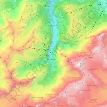
Name: Lauterbrunnen topographic map, elevation, terrain.
Average elevation: 2,316 m
Minimum elevation: 661 m
Maximum elevation: 4,112 m

Click on the map to display elevation.
Name: Lauterbrunnen topographic map, elevation, terrain.
Average elevation: 2,316 m
Minimum elevation: 661 m
Maximum elevation: 4,112 m