
Bordeaux topographic map
Interactive map
Click on the map to display elevation.
About this map
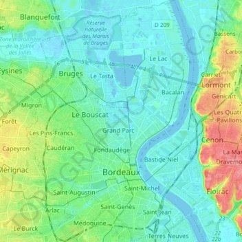
Name: Bordeaux topographic map, elevation, terrain.
Average elevation: 18 m
Minimum elevation: -4 m
Maximum elevation: 76 m
Other topographic maps
Click on a map to view its topography, its elevation and its terrain.
Grand Chemin
France > Nouvelle-Aquitaine > Gironde > Cadillac-en-Fronsadais
Grand Chemin, Cadillac-en-Fronsadais, Libourne, Gironde, Nouvelle-Aquitaine, Metropolitan France, 33240, France
Average elevation: 21 m
Arcachon
France > Nouvelle-Aquitaine > Gironde
Arcachon, Gironde, Nouvelle-Aquitaine, Metropolitan France, 33120, France
Average elevation: 9 m