
Sierra Madre topographic map
Interactive map
Click on the map to display elevation.
About this map
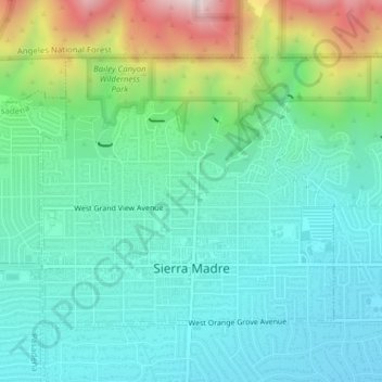
Name: Sierra Madre topographic map, elevation, terrain.
Location: Sierra Madre, California, 91024, United States of America (34.15682 -118.06821 34.17941 -118.02947)
Average elevation: 361 m
Minimum elevation: 174 m
Maximum elevation: 910 m
In 1908, the first Mt. Wilson Trail Race was run. This annual race was discontinued during WWII and reestablished in 1966. The 102nd anniversary of the first running of the Mount Wilson Trail Race and the 44th annual race was run in May 2010. Because of rain, mudslides, falling trees, soil erosion and rockslides, the regularly monitored trail course changes almost every year, and no official records of running times are kept. The 8.6-mile (13.8 km) course starts and ends on pavement, but most of the race is run on a dirt path about three feet wide, and the Mt. Wilson Trail has occasional steep vertical drops of hundreds of feet. Due to the trail's narrowness and steepness, the race is limited to 300 male and 300 female runners. The path gains elevation to more than 2,100 feet (640 m); at 4.3 miles (6.9 km) from the start of the race is Orchard Camp, the turnaround point. Scout troops hike up to provide water at two locations, at the 2.3-mile (3.7 km) point and at the Orchard Camp turnaround. The Sierra Madre Search and Rescue Team provides emergency support on race day. The Mt. Wilson Trail Race has traditional and historical value to the community.