
Södertälje topographic map
Interactive map
Click on the map to display elevation.
Södertälje
Due to its topography and the fact that it is divided by a canal, it has been difficult to build good train connections in and through the city. Despite this, Södertälje is one of the largest railway hubs in Sweden. When the railway to Södertälje was commissioned, it was decided that the main line would not be drawn through what was then the immediate city centre. The decision was one of the factors behind the urban planning of the area Mariekälla, just south of the Järnatullen city toll.
About this map
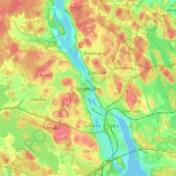
Name: Södertälje topographic map, elevation, terrain.
Average elevation: 32 m
Minimum elevation: -6 m
Maximum elevation: 99 m
Other topographic maps
Click on a map to view its topography, its elevation and its terrain.
Ekerö kommun
Ekerö is the only municipality in the Lake Mälaren region composed exclusively of islands. Land elevation has reduced the number of islands and skerries to 140, the largest of which are Adelsö, Munsö, Ekerö, Färingsö, and Lovö. 2000 years ago, during the Roman Iron Age, Färingsön was more of an…
Average elevation: 20 m
Södermalm
Sweden > Stockholm County > Stockholm
The name Södermalm (as Suthaermalm) is first mentioned in 1288 in a letter from Bishop Anund of Strängnäs. Until the early 17th century Södermalm was mainly a rural, agricultural area. Its first urban areas were planned and built in the mid 17th century, comprising a mixture of working class housing, such…
Average elevation: 22 m