
South Ayrshire topographic map
Interactive map
Click on the map to display elevation.
About this map
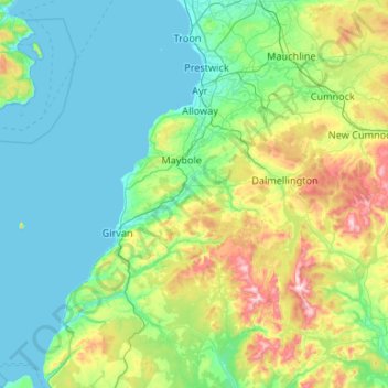
Name: South Ayrshire topographic map, elevation, terrain.
Location: South Ayrshire, Scotland, United Kingdom (54.99764 -5.06097 55.60187 -4.39886)
Average elevation: 151 m
Minimum elevation: 0 m
Maximum elevation: 834 m
The number of hours of natural sunshine in South Ayrshire is controlled by the length of day and by cloudiness. In general, December is the dullest month and May or June the sunniest. Sunshine duration decreases with increasing altitude, increasing latitude and distance from the coast. Local topography also exerts a strong influence and in the winter deep glens and north-facing slopes can be in shade for long periods. Industrial pollution and smoke haze can also reduce sunshine amounts, but the decline in heavy industry in the Ayrshire area, primarily in Ayr in South Ayrshire along with Kilmarnock in East Ayrshire, has resulted in an increase in sunshine duration particularly in the winter months.
Other topographic maps
Click on a map to view its topography, its elevation and its terrain.
Culteuchar
United Kingdom > Scotland > Perth and Kinross > Perth
Culteuchar, Perth, Perth and Kinross, Scotland, PH2 9HL, United Kingdom
Average elevation: 194 m
St Andrews
United Kingdom > Scotland > Fife
St Andrews, Fife, Scotland, KY16 9PA, United Kingdom
Average elevation: 38 m
Bridge of Earn
United Kingdom > Scotland > Perth and Kinross
Bridge of Earn, Perth and Kinross, Scotland, PH2 9PL, United Kingdom
Average elevation: 70 m
Millport
United Kingdom > Scotland > North Ayrshire
Millport, North Ayrshire, Scotland, KA28 0DL, United Kingdom
Average elevation: 11 m
Ben Cleuch
United Kingdom > Scotland > Clackmannanshire
Ben Cleuch, Clackmannanshire, Scotland, FK12 5HU, United Kingdom
Average elevation: 555 m
Stow
United Kingdom > Scotland > Scottish Borders
Stow, Scottish Borders, Scotland, TD1 2RE, United Kingdom
Average elevation: 268 m
Stob Choire Claurigh
United Kingdom > Scotland > Highland
Stob Choire Claurigh, Highland, Scotland, United Kingdom
Average elevation: 852 m
Aonach Beag
United Kingdom > Scotland > Highland
Aonach Beag, Highland, Scotland, United Kingdom
Average elevation: 825 m
Ballachulish
United Kingdom > Scotland > Highland
Ballachulish, Highland, Scotland, PH49 4JU, United Kingdom
Average elevation: 160 m
Aonach Mòr
United Kingdom > Scotland > Highland
Aonach Mòr, Highland, Scotland, United Kingdom
Average elevation: 533 m
Fingland
United Kingdom > Scotland > Dumfries and Galloway
Fingland, Dumfries and Galloway, Scotland, DG11 2LD, United Kingdom
Average elevation: 206 m
Loch Lochy
United Kingdom > Scotland > Highland
Loch Lochy, Highland, Scotland, United Kingdom
Average elevation: 363 m
Roybridge
United Kingdom > Scotland > Highland
Roybridge, Highland, Scotland, PH31 4AE, United Kingdom
Average elevation: 178 m
Seang Aonach Mor
United Kingdom > Scotland > Highland
Seang Aonach Mor, Highland, Scotland, United Kingdom
Average elevation: 895 m
Inverroy
United Kingdom > Scotland > Highland
Inverroy, Highland, Scotland, PH31 4AQ, United Kingdom
Average elevation: 167 m
Glen Nevis
United Kingdom > Scotland > Highland
Glen Nevis, Highland, Scotland, PH33 6TE, United Kingdom
Average elevation: 178 m
Strathcarron
United Kingdom > Scotland > Highland
Strathcarron, Highland, Scotland, IV54 8YR, United Kingdom
Average elevation: 91 m
Blacklaw
United Kingdom > Scotland > Scottish Borders
Blacklaw, Scottish Borders, Scotland, ML12 6QR, United Kingdom
Average elevation: 360 m
Abbey St. Bathans
United Kingdom > Scotland > Scottish Borders
Abbey St. Bathans, Scottish Borders, Scotland, TD11 3TX, United Kingdom
Average elevation: 212 m
Quothquan
United Kingdom > Scotland > South Lanarkshire
Quothquan, South Lanarkshire, Scotland, ML12 6FP, United Kingdom
Average elevation: 244 m
Muthill
United Kingdom > Scotland > Perth and Kinross
Muthill, Perth and Kinross, Scotland, PH5 2AW, United Kingdom
Average elevation: 85 m
West Linton
United Kingdom > Scotland > Scottish Borders
West Linton, Scottish Borders, Scotland, EH46 7ED, United Kingdom
Average elevation: 264 m
Glencotho
United Kingdom > Scotland > South Lanarkshire > Lanark
Glencotho, Lanark, South Lanarkshire, Scotland, ML11 7RB, United Kingdom
Average elevation: 196 m
Cappercleuch
United Kingdom > Scotland > Scottish Borders
Cappercleuch, Scottish Borders, Scotland, TD7 5LG, United Kingdom
Average elevation: 378 m
Durisdeer
United Kingdom > Scotland > Dumfries and Galloway
Durisdeer, Dumfries and Galloway, Scotland, DG3 5BJ, United Kingdom
Average elevation: 270 m
Ullapool
United Kingdom > Scotland > Highland
Ullapool, Highland, Scotland, IV26 2XE, United Kingdom
Average elevation: 150 m
Blairgowrie and Rattray
United Kingdom > Scotland > Perth and Kinross
Blairgowrie and Rattray, Perth and Kinross, Scotland, PH10 6AB, United Kingdom
Average elevation: 121 m
Eskdalemuir
United Kingdom > Scotland > Dumfries and Galloway
Eskdalemuir, Dumfries and Galloway, Scotland, DG13 0QF, United Kingdom
Average elevation: 246 m
Kerrera
United Kingdom > Scotland > Argyll and Bute > Oban
Kerrera, Oban, Argyll and Bute, Scotland, PA34 4SX, United Kingdom
Average elevation: 34 m
Ben More Assynt
United Kingdom > Scotland > Highland
Ben More Assynt, Highland, Scotland, United Kingdom
Average elevation: 679 m
Moniaive
United Kingdom > Scotland > Dumfries and Galloway
Moniaive, Dumfries and Galloway, Scotland, DG3 4HN, United Kingdom
Average elevation: 179 m
Lanark
United Kingdom > Scotland > South Lanarkshire
Lanark, South Lanarkshire, Scotland, ML11 7EX, United Kingdom
Average elevation: 206 m
Wolfhill
United Kingdom > Scotland > Perth and Kinross
Wolfhill, Perth and Kinross, Scotland, PH2 6TH, United Kingdom
Average elevation: 118 m
Forth
United Kingdom > Scotland > South Lanarkshire
Forth, South Lanarkshire, Scotland, ML11 8AA, United Kingdom
Average elevation: 267 m
Ladysbridge
United Kingdom > Scotland > Aberdeenshire
Ladysbridge, Aberdeenshire, Scotland, AB45 2JR, United Kingdom
Average elevation: 40 m
Arbroath
United Kingdom > Scotland > Angus
Arbroath, Angus, Scotland, DD11 1DP, United Kingdom
Average elevation: 24 m
Twechar
United Kingdom > Scotland > East Dunbartonshire
Twechar, East Dunbartonshire, Scotland, G65 9SA, United Kingdom
Average elevation: 64 m
Kirkwall
United Kingdom > Scotland > Orkney Islands
Kirkwall, Orkney Islands, Scotland, KW15 1DH, United Kingdom
Average elevation: 27 m
Nybster
United Kingdom > Scotland > Highland
Nybster, Highland, Scotland, KW1 4XR, United Kingdom
Average elevation: 30 m
Bridge of Allan
United Kingdom > Scotland > Stirling
Bridge of Allan, Stirling, Scotland, FK9 4HW, United Kingdom
Average elevation: 80 m
Loch Lomond and The Trossachs National Park
United Kingdom > Scotland > Stirling
Loch Lomond and The Trossachs National Park, Stirling, Scotland, United Kingdom
Average elevation: 291 m
Glen Coe
United Kingdom > Scotland > Highland > Glencoe
Glen Coe, Glencoe, Highland, Scotland, United Kingdom
Average elevation: 414 m
Gartmore
United Kingdom > Scotland > Stirling
Gartmore, Stirling, Scotland, FK8 3RW, United Kingdom
Average elevation: 55 m
Western Isles
Western Isles, Scotland, United Kingdom
Average elevation: 57 m
Boreray
United Kingdom > Scotland > Western Isles
Boreray, Western Isles, Scotland, HS6 5AJ, United Kingdom
Average elevation: 4 m
Irvine
United Kingdom > Scotland > North Ayrshire
Irvine, North Ayrshire, Scotland, KA12 0AX, United Kingdom
Average elevation: 13 m
Lochnagar
United Kingdom > Scotland > Aberdeenshire
Lochnagar, Aberdeenshire, Scotland, United Kingdom
Average elevation: 892 m
Braemar
United Kingdom > Scotland > Aberdeenshire
Braemar, Aberdeenshire, Scotland, AB35 5YN, United Kingdom
Average elevation: 445 m
Perth and Kinross
Perth and Kinross, Scotland, United Kingdom
Average elevation: 338 m
Forgandenny
United Kingdom > Scotland > Perth and Kinross
Forgandenny, Perth and Kinross, Scotland, PH2 9EQ, United Kingdom
Average elevation: 53 m