Blackwater River topographic map
Interactive map
Click on the map to display elevation.
About this map
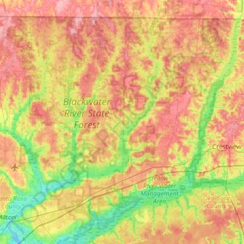
Name: Blackwater River topographic map, elevation, terrain.
Location: Blackwater River, Santa Rosa County, Florida, 32572, USA (30.58287 -87.03537 31.02867 -86.70921)
Average elevation: 47 m
Minimum elevation: -3 m
Maximum elevation: 96 m
Other topographic maps
Click on a map to view its topography, its elevation and its terrain.
St. Augustine
USA > Florida > St. Augustine
St. Augustine, St. Johns County, Florida, 32084, USA
Average elevation: 5 m
Dawson Island
USA > Florida > Jacksonville
Dawson Island, Jacksonville, Duval County, Florida, USA
Average elevation: 2 m
Dry Tortugas National Park
Dry Tortugas National Park, Monroe County, Florida, USA
Average elevation: 0 m
Deerfield Beach
USA > Florida > Deerfield Beach
Deerfield Beach, Broward County, Florida, USA
Average elevation: 5 m