
Switzerland topographic map
Interactive map
Click on the map to display elevation.
About this map
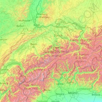
Name: Switzerland topographic map, elevation, terrain.
Location: Switzerland (45.81797 5.95591 47.80846 10.49229)
Average elevation: 1,016 m
Minimum elevation: 41 m
Maximum elevation: 4,564 m
Switzerland lies between latitudes 45° and 48° N, and longitudes 5° and 11° E. It contains three basic topographical areas: the Swiss Alps to the south, the Swiss Plateau or Central Plateau, and the Jura mountains on the west. The Alps are a mountain range running across the central and south of the country, constituting about 60% of the country's area. The majority of the population live on the Swiss Plateau. The Swiss Alps host many glaciers, covering 1,063 square kilometres (410 sq mi). From these originate the headwaters of several major rivers, such as the Rhine, Inn, Ticino and Rhône, which flow in the four cardinal directions, spreading across Europe. The hydrographic network includes several of the largest bodies of fresh water in Central and Western Europe, among which are Lake Geneva (Lac Léman in French), Lake Constance (Bodensee in German) and Lake Maggiore. Switzerland has more than 1500 lakes and contains 6% of Europe's freshwater stock. Lakes and glaciers cover about 6% of the national territory. Lake Geneva is the largest lake and is shared with France. The Rhône is both the main source and outflow of Lake Geneva. Lake Constance is the second largest and, like Lake Geneva, an intermediate step by the Rhine at the border with Austria and Germany. While the Rhône flows into the Mediterranean Sea at the French Camargue region and the Rhine flows into the North Sea at Rotterdam, about 1,000 kilometres (620 miles) apart, both springs are only about 22 kilometres (14 miles) apart in the Swiss Alps.
Other topographic maps
Click on a map to view its topography, its elevation and its terrain.
Chasiv Yar
Chasiv Yar, Chasiv Yar urban hromada, Bakhmut Raion, Donetsk Oblast, 84551-84556, Ukraine
Average elevation: 213 m
Ireland
Ireland
Average elevation: 44 m
Europe
Europe
Average elevation: 223 m
Valencia
Spain > Valencian Community > Comarca de València
Valencia, Comarca de València, Valencia, Valencian Community, Spain
Average elevation: 37 m
Cork
Ireland > County Cork > Cork
Cork, County Cork, Munster, T12 T997, Ireland
Average elevation: 94 m
Croatia
Croatia
Average elevation: 323 m
Dallas
United States > Texas > Dallas County
Dallas, Dallas County, Texas, United States
Average elevation: 160 m
Kazan
Russia > Tatarstan > городской округ Казань
Kazan, городской округ Казань, Tatarstan, Volga Federal District, Russia
Average elevation: 104 m
Rathcormack
Rathcormack, Drumcliff South, Drumcliff West ED, Sligo Municipal Borough District, County Sligo, Connacht, F91 PY24, Ireland
Average elevation: 27 m
Taiwan
Taiwan > Taiwan Province > Xinyi Township
Taiwan, Xinyi Township, Nantou County, Taiwan Province, Taiwan
Average elevation: 196 m
Monterey County
Monterey County, California, United States
Average elevation: 282 m
São José dos Campos
Brazil > São Paulo > Região Metropolitana do Vale do Paraíba e Litoral Norte
São José dos Campos, Região Imediata de São José dos Campos, Região Metropolitana do Vale do Paraíba e Litoral Norte, Região Geográfica Intermediária de São José dos Campos, São Paulo, Southeast Region, Brazil
Average elevation: 824 m
Bangladesh
Bangladesh
Average elevation: 161 m
Corvallis
United States > Oregon > Benton County
Corvallis, Benton County, Oregon, United States
Average elevation: 81 m
Toliara
Toliara, Atsimo-Andrefana, Province de Toliara, 601, Madagascar
Average elevation: 38 m
Latvia
Latvia
Average elevation: 72 m
Innichen - San Candido
Italy > Trentino – Alto Adige/Südtirol > South Tyrol
Innichen - San Candido, Pustertal - Val Pusteria, South Tyrol, Trentino – Alto Adige/Südtirol, 39038, Italy
Average elevation: 1,791 m
Madagascar
Madagascar
Average elevation: 139 m
Czechia
Czechia
Average elevation: 369 m
Slaney
Slaney, Newtownbarry ED, The Municipal District of Enniscorthy, County Wexford, Leinster, Y21 E1T6, Ireland
Average elevation: 50 m
Saint Petersburg
Saint Petersburg, Northwestern Federal District, Russia
Average elevation: 17 m
Ban Phayom
Thailand > Phayom Subdistrict Administrative Organization > Phayom Subdistrict
Ban Phayom, Phayom Subdistrict, Phayom Subdistrict Administrative Organization, Wang Noi District, Phra Nakhon Si Ayutthaya Province, 13170, Thailand
Average elevation: 4 m
Navvy Jack Point Park
Canada > British Columbia > Metro Vancouver Regional District > West Vancouver
Navvy Jack Point Park, Ambleside, West Vancouver, Metro Vancouver Regional District, British Columbia, Canada
Average elevation: 23 m
El Dorado County
El Dorado County, California, United States
Average elevation: 1,286 m
Victorville
United States > California > San Bernardino County
Victorville, San Bernardino County, California, United States
Average elevation: 920 m
Ubrique
Spain > Andalusia > Sierra de Cádiz
Ubrique, Sierra de Cádiz, Cádiz, Andalusia, 11600, Spain
Average elevation: 612 m
El Salvador
El Salvador
Average elevation: 484 m
Newburyport
United States > Massachusetts > Essex County > Newburyport
Newburyport, Essex County, Massachusetts, 01950, United States
Average elevation: 9 m
Anne Arundel County
Anne Arundel County, Maryland, United States
Average elevation: 25 m
Culleenatreen
Culleenatreen, Danesfort ED, Boyle Municipal District, County Roscommon, Connacht, Ireland
Average elevation: 65 m
Wangal
Philippines > Benguet > La Trinidad
Wangal, La Trinidad, Benguet, Cordillera Administrative Region, 2601, Philippines
Average elevation: 1,342 m
Sochi
Russia > Krasnodar Krai > Resort Town of Sochi (municipal formation)
Sochi, Resort Town of Sochi (municipal formation), Krasnodar Krai, Southern Federal District, Russia
Average elevation: 515 m
Black Forest
Black Forest, Baden-Württemberg, Germany
Average elevation: 471 m
San Bernardino County
San Bernardino County, California, United States
Average elevation: 763 m
Port Saint Lucie
United States > Florida > Saint Lucie County
Port Saint Lucie, Saint Lucie County, Florida, United States
Average elevation: 7 m
Oakton
United States > Virginia > Fairfax County
Oakton, Fairfax County, Virginia, 20030, United States
Average elevation: 114 m