
Chirumhanzu topographic map
Interactive map
Click on the map to display elevation.
About this map
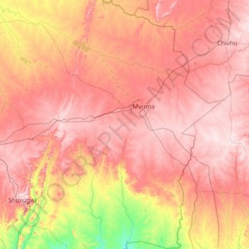
Name: Chirumhanzu topographic map, elevation, terrain.
Location: Chirumhanzu, Midlands, Zimbabwe (-19.86905 30.05655 -18.84250 30.88245)
Average elevation: 1,318 m
Minimum elevation: 1,020 m
Maximum elevation: 1,557 m
Other topographic maps
Click on a map to view its topography, its elevation and its terrain.