
Uttarakhand topographic map
Interactive map
Click on the map to display elevation.
About this map
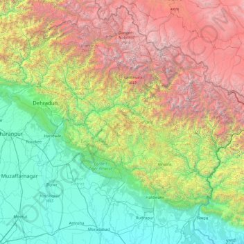
Name: Uttarakhand topographic map, elevation, terrain.
Location: Uttarakhand, India (28.72432 77.57133 31.45902 80.87852)
Average elevation: 2,107 m
Minimum elevation: 170 m
Maximum elevation: 7,657 m
Uttarakhand lies on the southern slope of the Himalaya range, and the climate and vegetation vary greatly with elevation, from glaciers at the highest elevations to subtropical forests at the lower elevations. The highest elevations are covered by ice and bare rock. Below them, between 3,000 and 5,000 metres (9,800 and 16,400 ft) are the western Himalayan alpine shrub and meadows. The temperate western Himalayan subalpine conifer forests grow just below the tree line. At 3,000 to 2,600 metres (9,800 to 8,500 ft) elevation they transition to the temperate western Himalayan broadleaf forests, which lie in a belt from 2,600 to 1,500 metres (8,500 to 4,900 ft) elevation. Below 1,500 metres (4,900 ft) elevation lie the Himalayan subtropical pine forests. The Upper Gangetic Plains moist deciduous forests and the drier Terai-Duar savanna and grasslands cover the lowlands along the Uttar Pradesh border in a belt locally known as Bhabar. These lowland forests have mostly been cleared for agriculture, but a few pockets remain.
Other topographic maps
Click on a map to view its topography, its elevation and its terrain.
Arasikere
India > Karnataka > Arasikere taluku
Arasikere, Arasikere taluku, Hassan District, Karnataka, 573103, India
Average elevation: 835 m
Sangareddy
India > Telangana > Sangareddy mandal
Sangareddy, Sangareddy mandal, Sangareddy District, Telangana, 502001, India
Average elevation: 517 m
Kodaikanal
Kodaikanal, Dindigul District, Tamil Nadu, India
Average elevation: 869 m
Majri
India > Punjab > Samana Tahsil
Majri, Samana Tahsil, Patiala District, Punjab, India
Average elevation: 244 m
Samana
India > Madhya Pradesh > Devendranagar Tahsil > Samana
Samana, Devendranagar Tahsil, Panna District, Madhya Pradesh, India
Average elevation: 326 m
Kawant
India > Gujarat > Kavant Taluka
Kawant, Kavant Taluka, Chhota Udaipur District, Gujarat, 391170, India
Average elevation: 200 m
Kishorganj
India > Madhya Pradesh > Rajnagar Tahsil > Bamitha
Kishorganj, Bamitha, Rajnagar Tahsil, Chhatarpur District, Madhya Pradesh, India
Average elevation: 245 m
Perumpetty
India > Kerala > Mallappally
Perumpetty, Mallappally, Pathanamthitta District, Kerala, India
Average elevation: 89 m
Kameswaram
India > Tamil Nadu > Kilvelur
Kameswaram, Kilvelur, Nagapattinam District, Tamil Nadu, 611110, India
Average elevation: 2 m
Bengaluru
India > Karnataka > Bangalore North
Bengaluru, Bangalore North, Bangalore Urban, Karnataka, India
Average elevation: 881 m
Puducherry
India > Puducherry > Puducherry Taluk
Puducherry, Puducherry Taluk, Puducherry District, Puducherry, 605001, India
Average elevation: 10 m
Badrinath
India > Uttarakhand > Joshimath Tehsil
Badrinath, Joshimath Tehsil, Chamoli District, Uttarakhand, India
Average elevation: 4,052 m
Faridpur
Faridpur, Bareilly District, Uttar Pradesh, India
Average elevation: 164 m
Barmer
India > Rajasthan > Barmer Tehsil
Barmer, Barmer Tehsil, Barmer District, Rajasthan, 344001, India
Average elevation: 188 m
Dubli
India > Madhya Pradesh > Tarana Tahsil > Dubli
Dubli, Tarana Tahsil, Ujjain District, Madhya Pradesh, India
Average elevation: 494 m
Mokila
India > Telangana > Shankarpalle mandal
Mokila, Shankarpalle mandal, Ranga Reddy District, Telangana, India
Average elevation: 569 m
Udaipur
Udaipur, Lahul and Spiti, Himachal Pradesh, India
Average elevation: 4,552 m
Koduvally
India > Kerala > Thamarassery
Koduvally, Thamarassery, Kozhikode district, Kerala, 673572, India
Average elevation: 41 m
Boys Company
India > Tamil Nadu > Coonoor
Boys Company, Coonoor, The Nilgiris District, Tamil Nadu, 643231, India
Average elevation: 1,881 m
Pykara
India > Tamil Nadu > Udhagamandalam
Pykara, Udhagamandalam, The Nilgiris District, Tamil Nadu, India
Average elevation: 2,104 m
Gudalur
Gudalur, The Nilgiris District, Tamil Nadu, India
Average elevation: 1,133 m
Bareilly
Bareilly, Bareilly District, Uttar Pradesh, India
Average elevation: 172 m
Kundalika Valley view point
India > Maharashtra > Mulshi > Pimpri
Kundalika Valley view point, Andharban Trail, Pimpri, Mulshi, Pune, Maharashtra, India
Average elevation: 679 m
Leh
India > Ladakh > Leh Tehsil
Leh, Leh Tehsil, Leh district, Ladakh, India
Average elevation: 3,653 m
Vattappara
India > Kerala > Nedumangad
Vattappara, Nedumangad, Thiruvananthapuram, Kerala, 695028, India
Average elevation: 87 m
Hyati
India > Karnataka > Koppala taluku
Hyati, Koppala taluku, Koppal district, Karnataka, India
Average elevation: 509 m
Sahibzada Ajit Singh Nagar
Sahibzada Ajit Singh Nagar, Punjab, India
Average elevation: 311 m
Pudukkottai
India > Tamil Nadu > Pudukkottai taluk
Pudukkottai, Pudukkottai taluk, Pudukkottai District, Tamil Nadu, India
Average elevation: 96 m