Geolocate

Rotterdam topographic map

Interactive map

Click on the map to display elevation.

About this map

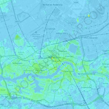
Name: Rotterdam topographic map, elevation, terrain.

Location: Rotterdam, South Holland, Netherlands (51.86167 4.37931 51.99428 4.60181)

Average elevation: 0 m

Minimum elevation: -8 m

Maximum elevation: 21 m

Other topographic maps

Click on a map to view its topography, its elevation and its terrain.

Zoetermeer

Netherlands > South Holland > Zoetermeer

Zoetermeer, South Holland, Netherlands

Average elevation: -3 m

Delft

Netherlands > South Holland > Delft

Delft, South Holland, Netherlands

Average elevation: 0 m

Oud Ade

Netherlands > South Holland

Oud Ade, Kaag en Braassem, South Holland, Netherlands

Average elevation: -2 m

Goeree-Overflakkee

Netherlands > South Holland

Goeree-Overflakkee, South Holland, Netherlands

Average elevation: 0 m

Vredepolder

Netherlands > South Holland > Barendrecht

Vredepolder, Barendrecht, South Holland, Netherlands

Average elevation: 1 m

Krimpenerwaard

Netherlands > South Holland > Krimpenerwaard

Krimpenerwaard, South Holland, Netherlands

Average elevation: -1 m