
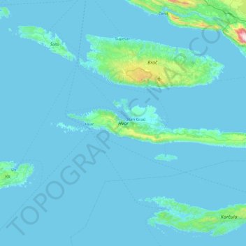
Hvar topographic map
Interactive map
Click on the map to display elevation.
About this map
Name: Hvar topographic map, elevation, terrain.
Location: Hvar, Split, Split-Dalmatia County, 21000, Croatia (43.11218 16.36633 43.23568 17.19672)
Average elevation: 58 m
Minimum elevation: -2 m
Maximum elevation: 1,574 m
The island has a typical Mediterranean vegetation, mostly bare with woody scrub at higher, steeper elevations, turning to pine forests on the lower slopes with Holm oak (Orno-Quercetum ilicis), Aleppo pines (Pinus halapensis Mill) and Black pines (Pinus nigra dalmatica). The islet of Šćedro is especially rich in various Mediterranean trees and plants.
Other topographic maps
Click on a map to view its topography, its elevation and its terrain.