
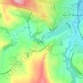
Waterfall topographic map
Interactive map
Click on the map to display elevation.
About this map
Name: Waterfall topographic map, elevation, terrain.
Average elevation: 251 m
Minimum elevation: 158 m
Maximum elevation: 407 m
Other topographic maps
Click on a map to view its topography, its elevation and its terrain.
Burbage
United Kingdom > England > High Peak > Burbage
Burbage, High Peak, Derbyshire, East Midlands, England, SK17 6UN, United Kingdom
Average elevation: 382 m
Kinder Scout
United Kingdom > England > High Peak
Kinder Scout, High Peak, Derbyshire, East Midlands, England, S33 7ZJ, United Kingdom
Average elevation: 557 m